What to see
Visiting Twyfelfontein: petroglyphs and wonders of Damaraland
We may earn a commission when you book through links on this page, at no extra cost to you. We don't visit or try the places we cover: we summarize published sources. How we work
In short
- The petroglyph site is visited only with an accredited local guide (1 h 30 to 2 h), open 8 am to 5 pm; about N$270 per adult from January 2026.
- Windhoek to Twyfelfontein is about 490 to 550 km (305 to 342 mi), 6 to 7 hours; fill up at Khorixas, the last reliable fuel station before the site.
- The Organ Pipes and Burnt Mountain, about 6 km (4 mi) away, take under an hour together; the Petrified Forest is 35 to 40 km (22 to 25 mi) northwest.
- Best period is May to October; November to March brings intense heat of 35 to 42 °C (95 to 108 °F).
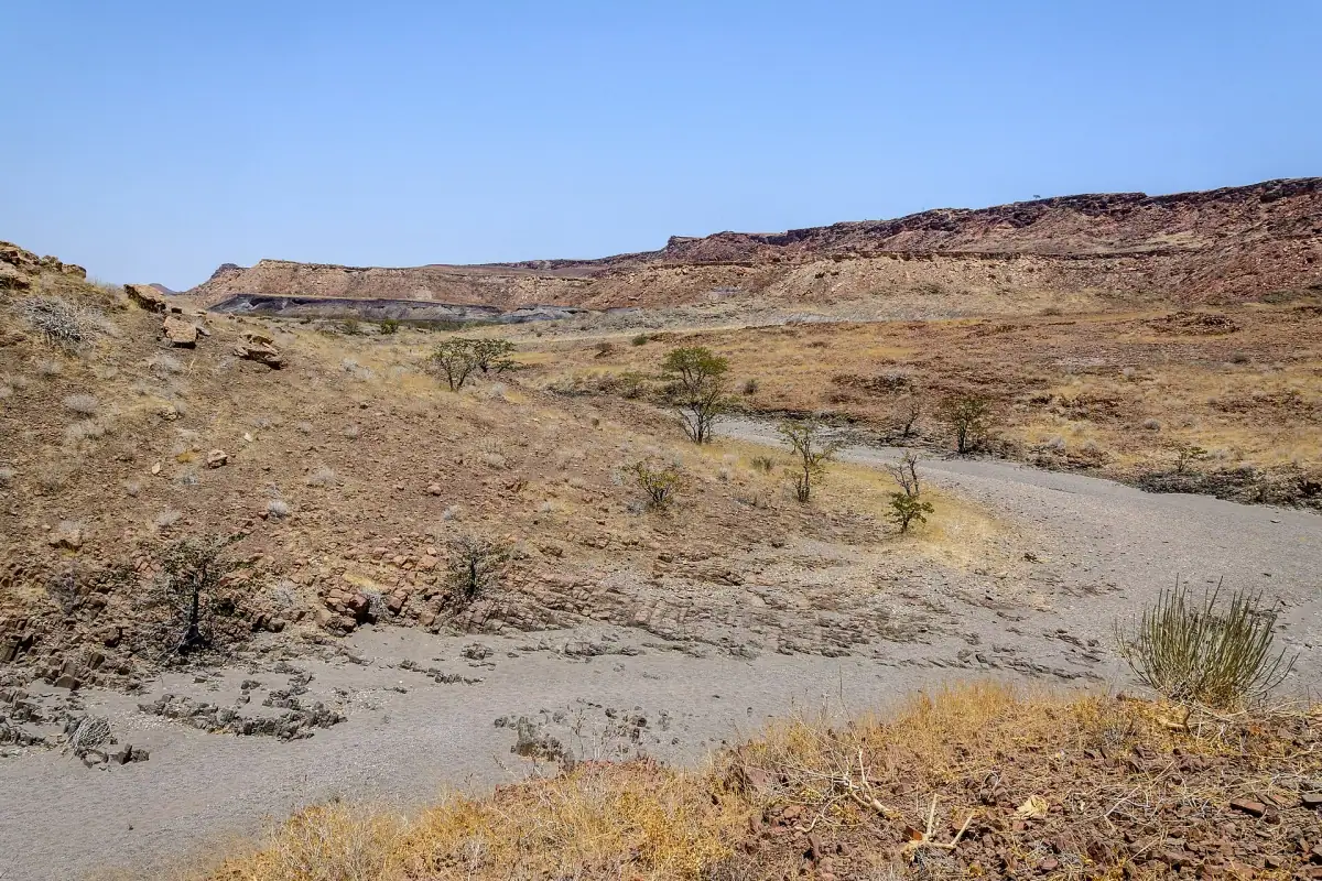
In Damaraland, a vast desert region of northwestern Namibia, lies one of the most remarkable archaeological treasures in Africa. Twyfelfontein, “doubtful spring” in Afrikaans, named by a white farmer who doubted the spring was reliable enough to last, is now a UNESCO World Heritage site. Not for architecture or a built monument, but for thousands of rock engravings cut into the stone by San hunter-gatherers between 10,000 and 1,000 years ago. Rhinos, lions with human paws, giraffes, elephants and animal tracks: it is an open picture book of Namibian prehistory.
But Twyfelfontein is only a gateway. The Damaraland around it is an extraordinary region: basalt organ pipes rising from the rock, a scorched mountain in unreal colors, a forest of petrified trunks 280 million years old, desert-adapted elephants and Himba communities living by age-old traditions. It is one of the most spectacular areas of Namibia, and one of the least visited.
An exceptional prehistoric site: 6,000 years of engraved memory
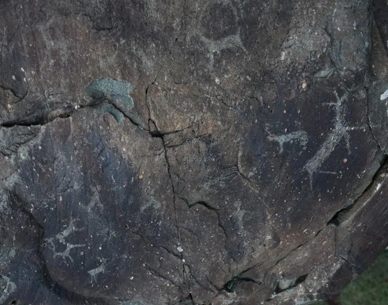
Twyfelfontein is the largest known group of petroglyphs (rock engravings) in Africa, with more than 5,000 engravings spread over about ten rock panels. The red sandstone slabs, heated by the sun and tilted at different angles, served for millennia as a canvas for the San artists who lived in this valley of the Aba Huab river.
The engravings cover a period from 10,000 to 1,000 years ago, with most created between 6,000 and 2,000 years ago (roughly 4000 BC to 0 AD). They mainly depict local wildlife: white and black rhinos, lions, leopards, elephants, giraffes, mountain zebras, springbok and ostriches. But several engravings are more symbolic and shamanic in nature: lions with human-like paws, half-human half-animal beings, and sequences of animal tracks winding from slab to slab like a map or a hunting tale.
The Lion Panel, in the center of the site, is the most famous. It clearly shows a lion whose hind legs end in human footprints, a shamanic figure that specialists interpret as the depiction of a healer in a trance, “becoming” the animal to communicate with the spirit world. The Elephant Panel shows a parade of pachyderms engraved with stunning anatomical precision. The Giraffe Panel, at the bottom of the site, has adult-sized and young giraffes.
Twyfelfontein was inscribed as a UNESCO World Heritage site in 2007, the first Namibian site to receive this status. The visitor center, renovated in 2020, has an excellent introductory exhibition on the San, their way of life and the interpretation of the engravings, worth seeing before you climb up to the site.
Guided excursions in Damaraland
Petroglyph tours, desert elephant tracking and Damaraland safaris from Twyfelfontein.
How to visit the Twyfelfontein site
Practical information and prices
The site is managed by the Namibia Tourism Board. The guided visit is mandatory since the UNESCO listing; you cannot reach the slabs alone. The local guides, all accredited and often descendants of Damara or San families from the area, are excellent. They link the abstract engravings to traditional beliefs with contagious passion.
- Hours: open daily 8 am to 5 pm (last entry 3:30 pm)
- Visit length: 1 h 30 to 2 h minimum (allow 3 h for enthusiasts)
- Price: about N$270 per adult (from January 2026), N$80 for children aged 6 to 16
- Groups: maximum 10 people per guide; in high season (July to August), arrive early to avoid waiting
The climb up to the site
The climb from the visitor center to the main slabs takes 15 minutes on a marked and well-maintained trail. The elevation gain is moderate, but the sandstone slabs can be slippery when wet (very rare). The whole guided route covers about 1.5 km (0.9 mi) over varied terrain. Wear closed walking shoes; flip-flops are not recommended.
The temperature rises fast on the rocks. In summer (October to March), humidity and heat combined (35 to 42 °C / 95 to 108 °F) can make the climb grueling. Bring at least 1.5 liters (0.4 US gal) of water per person, even in winter.
Photographing the petroglyphs
Photography is free and encouraged. A few rules to follow absolutely: never touch the engravings (skin oils speed up their degradation), do not sit on them, do not walk off the marked paths. Site rangers enforce these rules.
The raking light of morning (8 to 10 am) and evening (3 to 5 pm) gives the best photographic conditions: the carved engravings fill with shadow and stand out with striking depth. Avoid the harsh light from 11 am to 2 pm.
The Organ Pipes and Burnt Mountain: a surreal volcanic landscape
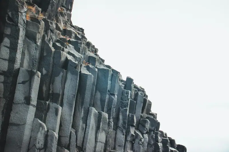
About 6 km (4 mi) from the petroglyph site, two geological curiosities complete the visit spectacularly.
The Organ Pipes
A 500 m (1,640 ft) trail from the parking leads to a narrow gorge where a flow of dolerite (intrusive volcanic rock) solidified about 132 million years ago (Early Cretaceous) into perfectly regular vertical columns. These hexagonal columns, 4 to 6 meters (13 to 20 ft) high, look just like the pipes of an immense cathedral organ. The contrast between the red-ocher of the surrounding sandstone and the black-gray of the dolerite is striking.
The site is freely accessible (no extra ticket). The best light is again in late afternoon, when the sun sinks in line with the gorge.
Burnt Mountain
About 1 km (0.6 mi) from the Organ Pipes, Burnt Mountain is a volcanic hill whose rocks, rich in iron and manganese ores, have taken on shades of brown, purple, red and black that give the illusion of a scorched mountain. There was no fire: it is the contact metamorphism of the volcanic intrusion that baked the sediments millions of years ago.
The mountain is particularly photogenic at sunset, when the mineral colors blaze in the golden light. A 20-minute path from the parking lets you climb the first foothills for a panoramic view of the valley.
The Organ Pipes and Burnt Mountain can be visited together in under an hour; the detour is a must-do if you are at Twyfelfontein anyway.
Lodges and campsites in Damaraland
From luxury lodge to wild camping, all the accommodation around Twyfelfontein.
The Khorixas Petrified Forest: 280 million years of history
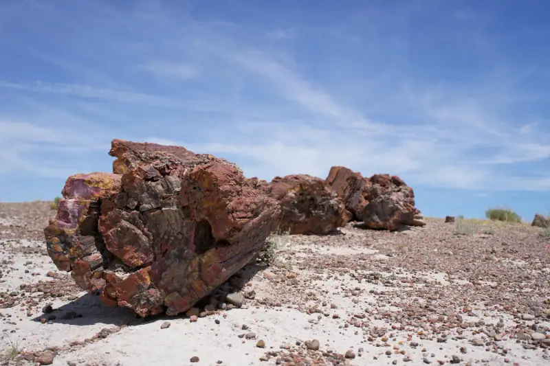
About 42 km (26 mi) west of Khorixas, or about 35 to 40 km (22 to 25 mi) northwest of Twyfelfontein via the D2612, the Petrified Forest is another spectacular site often paired with a Twyfelfontein visit. This natural monument holds petrified tree trunks dating back to the Permian (about 280 million years ago), scattered over an area of about 24 hectares (60 acres; 300 m × 800 m) in a dry riverbed.
These trunks, sometimes 30 to 45 meters (98 to 148 ft) long, belonged to a tree species called Cordaites, a primitive conifer that shares a common ancestor with modern firs and spruces, which grew in immense forests when the Gondwana continent was still intact. The trees were swept away by catastrophic floods, then covered with sediment before being mineralized: silica gradually replaced the organic matter, preserving the structure of the wood with absolute fidelity. You can still see the growth rings, bark and knots.
- Visits: guided only (accredited local guides, about N$250 to 270 per adult, rate to be confirmed locally)
- Duration: 45 minutes to 1 h 15
- Condition: excellent (protected site, collecting forbidden)
The Petrified Forest is less known on standard circuits but is a major stop for understanding Namibia’s geological history.
Desert elephants and Damaraland wildlife
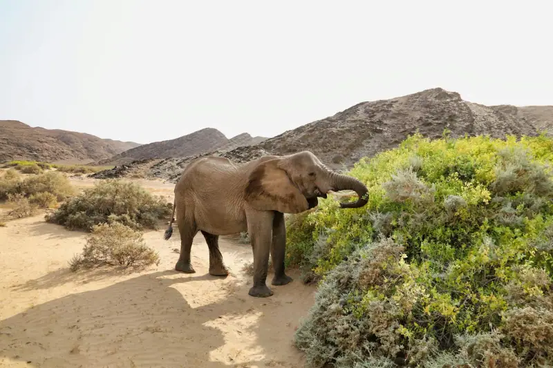
Damaraland is one of the few places in the world to see desert elephants. They are not a distinct subspecies but African elephants (Loxodonta africana) that have developed remarkable behavioral and morphological adaptations to survive in a semi-arid environment: slightly wider feet for walking on sand and rock, larger fat reserves, and the ability to go several days without water, making do with the moisture in plants.
They mainly frequent the Huab valley (6 km / 4 mi from Twyfelfontein via Aba Huab Campsite) and the area around Palmwag, about 105 to 130 km (65 to 81 mi) to the north (2 h 30 to 3 h by road). Estimates vary by source, from a few dozen to about 150 to 200 individuals (check the latest counts), after a decline linked to droughts, poaching and human-elephant conflict. Local trackers working for the region’s lodges offer outings from dawn; the elephants are active early in the morning near waterholes.
Other wildlife to see in Damaraland
- Desert black rhinos: one of the last free-ranging populations in the world, in the Palmwag area (access with an approved guide only)
- Oryx (gemsbok): everywhere on the tracks and roads
- Springbok, Hartmann’s mountain zebra: frequent in the valleys
- Common eland: more discreet, often spotted at dawn
- Raptors: bateleur eagle, African vulture, pearl-spotted owlet
The Himba communities of Damaraland
Damaraland and its immediate surroundings are the historic territory of the Himba, one of the last semi-nomadic communities in Africa to have preserved a traditional way of life. Himba women are famous for their skin and hair coated in otjize, a mixture of animal fat (goat or cow butterfat), red ocher and aromatic herbs or resins, which protects them from the sun and gives them that unmistakable coppery tint.
Several villages around Twyfelfontein and Khorixas welcome visitors as part of community-based tourism. These visits, organized with the consent of the communities and led by local guides, let you observe daily life: making otjize, building huts of mud and cow dung, everyday rituals, crafts.
Important: avoid unguided visits or spontaneous stops in villages without a guide; this is considered intrusive and disrespectful. Go through your lodge or an accredited operator. To go further, our guide to Himba traditions in Namibia details the cultural codes to know before your visit.
Car rental in Namibia
Essential for Damaraland: compare 4x4s and off-road vehicles from Windhoek.
Where to stay in Damaraland
Accommodation in Damaraland ranges from rustic camping under the stars to some of the most exclusive luxury lodges in southern Africa.
High-end accommodation
Mowani Mountain Camp is the reference lodge in the Twyfelfontein area. Perched on granite rocks, with panoramic dome tents open to the valley, it offers a 360° view over Damaraland. Fine-dining restaurant, pool, guided petroglyph and elephant outings included. Allow €350 to 500 (about $405 to 580) per night in high season.
Twyfelfontein Country Lodge is the closest option to the UNESCO site, about 4 km (2.5 mi) away. Comfortable chalets, pool, decent restaurant. Good value for the level of comfort offered (€180 to 260, about $210 to 300, per night).
Desert Rhino Camp (Palmwag area) is the ideal base for combining black rhino tracking and desert elephants. Tents with a view of the plain, conservation activities included. Farther away (80 km / 50 mi north) but exceptional for wildlife.
Camping
Aba Huab Campsite, run by the local community, is 6 km (4 mi) from Twyfelfontein. Sites with a basic restroom block, braai (barbecue) and open views. Allow N$200 to 350 per site for two people.
Twyfelfontein Adventure Camp offers budget chalets and campsites in the valley, 3 km (1.9 mi) from the site.
Getting there and logistics
From Windhoek (~490 to 550 km / 305 to 342 mi depending on the route)
The most common route: B1 north to Otjiwarongo (250 km / 155 mi, paved road, about 2 h 30), then C35 west to Khorixas (about 200 km / 124 mi, road sometimes gravel but of good quality), then D3254 south to Twyfelfontein (about 98 to 100 km / 61 to 62 mi of good track). Total time: 6 to 7 hours.
Fill up at Khorixas without exception: it is the last reliable fuel station before the site. In high season (July to August), leave Windhoek at 7 am at the latest to arrive before the afternoon heat.
From Swakopmund (~350 km / 217 mi)
Swakopmund is an excellent base for approaching Damaraland from the west. Take the C28 north (Uis, Brandberg) then the D2612 to the Petrified Forest and the C35 toward Twyfelfontein. This route lets you combine Brandberg, the Petrified Forest and Twyfelfontein in two days. Allow about 330 km (205 mi) and 3 h 45 to 4 h from Swakopmund (plus stops).
Do you need a 4x4?
Not necessarily. In the dry season (May to October), a standard sedan or SUV is enough on the D3254 and C35 if they are in good condition. In the rainy season (November to April), tracks can be cut by sudden floods. A high-clearance 4x4 is still highly recommended to explore the surroundings (Petrified Forest, Palmwag, Himba villages). See our Namibia road trip guide for the best rental options.
Best time to visit Damaraland
Damaraland is a semi-arid region. Temperatures and rainfall vary strongly with the seasons.
Best period: May to October
This dry season offers the best conditions: pleasant temperatures (20 to 28 °C / 68 to 82 °F by day, 10 to 15 °C / 50 to 59 °F at night in winter), passable tracks, dry vegetation (better wildlife visibility), perfectly clear skies. July and August are the busiest months; book your lodges 3 to 6 months ahead.
April to May is the ideal period for photographers: the brief rainy season (March to April) has greened the landscape, the acacias are in flower, and tourists are still few. Tracks are generally passable from late April.
November to March: intense heat (35 to 42 °C / 95 to 108 °F by day), some thunderstorms in January to March, tracks sometimes cut. Reserved for hardy travelers who can handle the logistics.
Practical tips and budget
Estimated daily budget in Damaraland:
- Budget: N$800 to 1,200 per day (camping, self-catering, site entries)
- Comfort: N$1,500 to 3,000 per day (country lodge, restaurant meals, guides)
- Luxury: N$5,000 to 8,000 per day and more (exclusive camps, activities included)
What to bring:
- Plenty of water (at least 3 L / 0.8 US gal per person per day in summer)
- Fuel jerrycans if you explore beyond Khorixas
- Food and snacks for 2 days (no supermarket in Damaraland)
- SPF 50+ sunscreen, wide-brimmed hat, sunglasses
- A complete first-aid kit
- Offline map (Maps.me or OsmAnd); there is no GSM network in most of the area
Network and connection: MTC coverage is available at Khorixas and intermittently in Damaraland. Expect no signal between lodges. That is also what gives the starry nights their charm here. Check your carrier’s international plan or consider a travel eSIM for the places that do have coverage.
Safety: the region is very safe. The main risk is logistical (breakdown in an isolated area, heat). Always tell your lodge or someone else your route.
Entry fees and permits: apart from the Twyfelfontein site (N$270) and the Petrified Forest (about N$250 to 270, to be confirmed locally), access to the tracks is free. The Palmwag area for black rhinos requires authorization from the Save the Rhino Trust, to be arranged through your lodge.
Twyfelfontein is not the Namibia of classic safaris. No big herd, no lioness lying on a kopje in full sun. It is another Namibia, older, quieter, where the rocks speak a language six millennia old. The San engravings, the dolerite columns, the scorched mountain, the fossilized trunks, the ghost elephants crossing the valley at dawn: Damaraland offers a rare travel experience, that of a landscape that has not changed since time immemorial.
To structure your trip, see our guides to the Namibia road trip and the Skeleton Coast, which together with Damaraland form the great circuit of northwestern Namibia.
Frequently asked questions
How long do you need to visit Twyfelfontein?
Allow half a day for the petroglyph site (1 h 30 to 2 h guided visit), plus an extra hour for the nearby Organ Pipes and Burnt Mountain. If you combine it with the Petrified Forest and a desert elephant outing, plan two full days in the Damaraland region.
How do you get to Twyfelfontein from Windhoek?
Twyfelfontein is about 490 to 550 km (305 to 342 mi) from Windhoek depending on the exact route, or 6 to 7 hours by road. Take the B1 north to Otjiwarongo, then the C35 west via Khorixas. The last stretch (D3254) is a gravel track passable without a 4x4 in the dry season. Fill up at Khorixas, the last fuel station before the site.
Are visits to Twyfelfontein compulsorily guided?
Yes, the visit has been guided-only since the UNESCO listing in 2007. Accredited local guides take groups from 8 am to 5 pm (last entry 3:30 pm). The visit lasts 1 h 30 to 2 h. Guides speak English and Afrikaans. Rate: about N$270 per adult (from January 2026).
Can you see desert elephants from Twyfelfontein?
Desert elephants frequent the Huab valley and the Palmwag area, 1 to 2 hours by road from Twyfelfontein. They are among the few elephants in the world adapted to survive in a semi-arid environment. Local operators offer tracking outings from dawn. An encounter is never guaranteed, but the success rate is high from May to October.
Is Twyfelfontein suitable for families with children?
Yes, from age 6 or 7. The walk on the site is moderate (1 to 2 km / 0.6 to 1.2 mi over rock slabs). Bring plenty of water, closed shoes and strong sun protection. Children are usually fascinated by the animal depictions. Avoid November to January because of the excessive heat (38 to 42 °C / 100 to 108 °F).
What is the best time to photograph the petroglyphs?
Early morning (8 to 10 am) and late afternoon (3 to 5 pm) are ideal: the raking light brings out the engravings with striking depth. Avoid midday; overhead light flattens the relief and gives dull photos. Guides know the best compositions according to the position of the sun.
More Namibia guides
Keep reading
Visiting Etosha National Park: a complete guide to the Namibian safari
Complete guide to Etosha National Park: best season, camps, waterholes and animals to see. Everything to plan your safari in Namibia.
Visiting Lüderitz: a complete guide to the desert ghost town
Complete guide to Lüderitz: Kolmanskop, penguins, German architecture and the Namib Desert. All you need to visit this unique town in Namibia.
Visiting Swakopmund: a complete guide to Namibia's colonial pearl
Complete guide to Swakopmund: German architecture, sandboarding, Living Desert tours and restaurants. Everything to visit this unique Namibian town.
Ready-made
Namibia itineraries
10 days
Namibia in 10 days without a car: a realistic itinerary by shuttle and transfer
WindhoekEtoshaDamaralandSwakopmundSesriem / SossusvleiWindhoek
10 days
Namibia road trip in the rainy season (January to March): itinerary and passable roads
WindhoekEtosha (Okaukuejo)Khorixas / TwyfelfonteinSwakopmundSesriemWindhoek

21 days
Namibia road trip: a complete 2 to 3 week 4x4 itinerary
WindhoekSossusvlei / Namib-NaukluftSwakopmund / Walvis BayDamaraland / SpitzkoppeTwyfelfonteinSkeleton Coast, southern partEtoshaWaterberg PlateauFish River CanyonLüderitz and return to Windhoek