What to see
What to see in the Esterel: Corniche d'Or, Agay, Cap Roux and Mont Vinaigre
We may earn a commission when you book through links on this page, at no extra cost to you. We don't visit or try the places we cover: we summarize published sources. How we work
In short
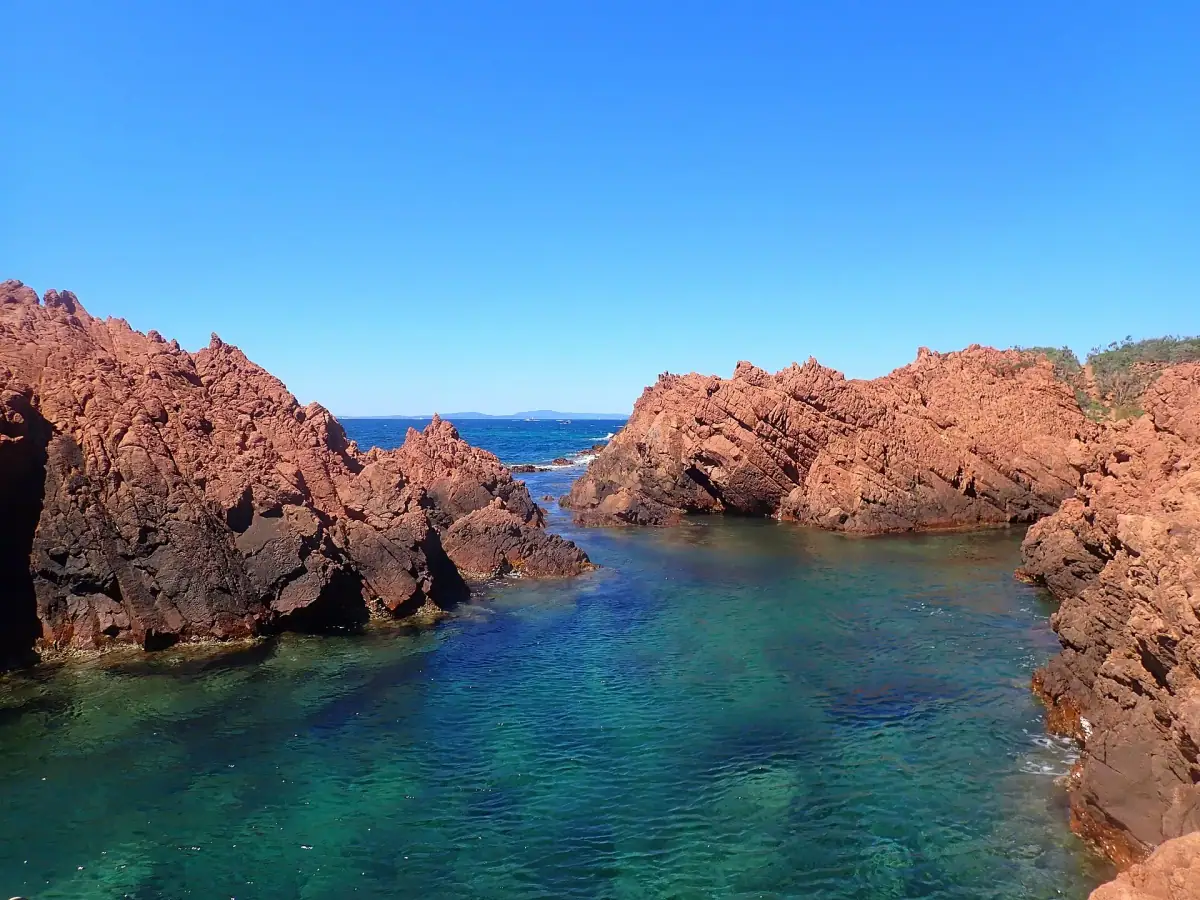
- The Esterel massif, about 15 km (9 mi) long and 10 km (6 mi) wide, lies between Cannes and Saint-Raphaël. Its red volcanic rocks drop straight into the sea.
- The Corniche d'Or is the coastal road between Mandelieu-la-Napoule and Saint-Raphaël. Leave early in July and August, when cove parking lots fill in the morning.
- Summit hikes: Pic du Cap Roux (about 450 m / 1,480 ft), Pic de l'Ours (about 490 m / 1,610 ft), Mont Vinaigre (just over 600 m / 1,970 ft).
- Access to the massif is regulated by fire risk, with a level published daily in dry periods. Check it the day before and the same morning; fires are strictly forbidden.
Between Cannes and Saint-Raphaël, the French Riviera changes character. Sand beaches and urban promenades give way to a volcanic massif of blood-red rock plunging straight into an intensely blue Mediterranean. This is the Esterel: porphyry cliffs, tiny coves, ridge trails, a forest of cork oaks and pines, and one of the most spectacular coastal roads in the south of France, the Corniche d’Or.
This guide presents what to see in the Esterel, how to organize your days, which hikes to choose for your level and, above all, how to respect the safety rules of this massif, which is sensitive to fire risk. We give no opening hours or prices, which vary by season: always check with tourist offices before you go. To complement it, our guide to the Cannes area covers the eastern part, and our hikes on the French Riviera give ideas for complementary trails.
The Esterel at a glance
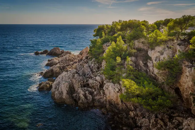
The Esterel massif is an ancient volcanic massif, several hundred million years old. It is formed mostly of rhyolites and red porphyries, from ancient eruptions whose main sites are around Agay and Mont Vinaigre. It extends about 15 km (9 mi) long and 10 km (6 mi) wide, in the continuation of the coast between Mandelieu-la-Napoule and Saint-Raphaël. A large part of the territory is classified or protected, and a significant share is state forest.
The landscape is the result of a contrast: red rocks, scrub and forests of cork oak, maritime pine and stone pine, with strawberry tree, heather, rockrose and, in places, mimosa. The vegetation is dense but dry in summer, which explains the vigilance about fires.
Here are the main stops, from east to west:
- Mandelieu-la-Napoule and Théoule-sur-Mer: the eastern gateway to the massif, with the Château de la Napoule, harbors and the first red coves.
- Le Trayas and Anthéor: small coastal hamlets clinging to the cliff, at the foot of Cap Roux.
- Agay: a sheltered bay dominated by the rocks of the Rastel, the starting point for many boat trips.
- Le Dramont: a cape, a semaphore, porphyry rocks and a view of the Île d’Or.
- The interior of the massif: Pic de l’Ours, Mont Vinaigre, Pic du Cap Roux, the former Lac de l’Écureuil and the site of the Malpasset dam.
- Saint-Raphaël, Boulouris and Valescure: the western gateway, on the Var side.
The Corniche d’Or, the most spectacular road
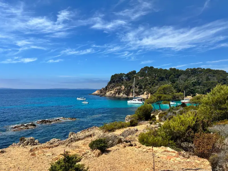
The Corniche d’Or, also called the Esterel corniche, is the seaside road that runs along the coast between Saint-Raphaël and Mandelieu-la-Napoule. It hugs the red cliff, passes above small bays, crosses hamlets, rounds rocky points and offers a new view of the sea at every bend. It is one of the most photogenic roads on the French Riviera.
To enjoy it without stress, a few simple rules:
- Allow plenty of time: the road is winding, often narrow, and traffic is slow in summer. The pleasure is in relaxed driving and the stops.
- Use the marked parking areas rather than stopping on the roadway. Wild parking is dangerous and fined.
- Leave early: in July and August, the cove parking lots fill from the morning.
- Watch for two-wheelers: the road is very popular with cyclists and motorcyclists.
If you do not want to drive, the train also runs along the coast with several small stations serving the hamlets: the trip is a spectacle in itself. Our guide to getting around the French Riviera without a car details the options and their limits.
Agay, the bay of red rocks
Agay is the best-known beach resort of the Esterel. It sits at the back of a sheltered natural bay, dominated by the Rastel, a group of red rocks that becomes almost incandescent at sunset. The bay is considered one of the most beautiful sites of the massif, and it is easy to see why: sand beach, calm water, small harbor, seafront restaurants and trails that start right from the village.
Agay suits a stay of several days well: it serves as a base for the beach, hiking and boat trips. The harbor is the departure point for many excursions to discover the coves from the sea: boat rides, boat rental, kayak or paddleboard. The water is generally calm, which suits families. Diving is also offered by local clubs, with introductory dives and courses.
Stay in Agay, at the foot of the red rocks
Agay is an excellent base for exploring the massif on foot and by boat. Accommodation fills fast in summer: compare offers and book early.
Le Dramont and the Île d’Or
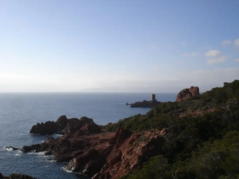
West of Agay, Cap du Dramont closes the Gulf of Fréjus. You reach it by a seaside trail that follows the red porphyry rocks, facing the Île d’Or. This islet, topped by a tower, is a visual landmark for the whole area. The Dramont semaphore, at the top of the cape, offers a panoramic viewpoint over the Maures range. Two porphyry rocks, the “Lion de Mer” and the “Lion de Terre”, guard the entrance to the Gulf of Fréjus.
It is a short, easy walk that suits most walkers and children, as long as you avoid the hottest hours. The cape also has a historical dimension: it is one of the places linked to the Provence landings of August 1944. Several steles and memorials recall that episode.
The big hikes: Cap Roux, Pic de l’Ours and Mont Vinaigre
The Esterel is a coastal mid-mountain massif. Its summits do not exceed 620 m (2,034 ft), but the elevation gains start almost from sea level, and the trails are sometimes steep, rocky and shadeless. Three outings come up again and again in guidebooks:
- Pic du Cap Roux (about 450 m / 1,480 ft): the most famous hike. It climbs from the Anthéor area and reveals a plunging view of the coast. On the flanks of Cap Roux, a cave called “Sainte-Baume” is associated with Saint Honoratus, who is said to have taken refuge there.
- Pic de l’Ours (about 490 m / 1,610 ft): a viewpoint recognizable by its rocky tip and its panorama over the sea and the hinterland.
- Mont Vinaigre (just over 600 m / 1,970 ft): the highest point of the massif. A viewing platform at the top lets you look over the whole Esterel. It is a longer outing, best on a clear day.
The trails are generally marked, but conditions vary: some stretches are steep, the rock is slippery after rain and water points are rare. Bring good hiking shoes, at least 1.5 to 2 liters (about 3 to 4 pints) of water per person, a hat and sun protection. Avoid the hot hours and never set off without checking the weather and the fire risk level. To compare with other routes in the region, our selection of coastal hikes helps you choose according to the effort you want.
Discover the Esterel coves from the sea
Boat ride, kayak or paddleboard: the red coast can also be discovered from the water, where the trails do not reach. Compare the outings offered and book ahead in season.
Mandelieu-la-Napoule and Théoule-sur-Mer
On the east side, the massif starts at Mandelieu-la-Napoule, just after Cannes. The port of La Napoule is dominated by a medieval castle transformed in the 20th century by an American sculptor, Henry Clews, into an art foundation, with very particular gardens and atmosphere. Visiting hours and prices vary: check the official website before you come.
Farther on, Théoule-sur-Mer stretches between red points, marinas and coves. The road becomes a genuine corniche here: villas clinging to the slope, bends above the water and small pocket beaches. It is a good starting point for the Corniche d’Or if you arrive from Cannes, and a pleasant stop for a late-morning swim. These two towns are also departure points for boat excursions along the red coast.
In the heart of the massif: forest, Lac de l’Écureuil and Malpasset
The interior of the Esterel is very different from the coast. Here, you walk under cork oaks and pines, on forest tracks and trails shaded in places, far from the noise of the coast. Several sites deserve a detour:
- The former Lac de l’Écureuil, in the middle of the forest, a quiet walking site: ask locally about the current state of the place.
- The ruins of the Malpasset dam, near Fréjus. This structure broke on December 2, 1959 after torrential rain, causing a disaster in the Reyran valley. The site, reached by a short walk from a parking lot, is not spectacular but very striking for its historical weight.
- Cycling and mountain-bike trails, plentiful but sometimes demanding. The massif lends itself well to cycling, horseback riding and walking for those looking for nature rather than the beach.
The massif is home to typical Mediterranean flora. In winter and spring, blooming mimosa colors the region yellow. In summer, the heat is strong and shade precious.
Fire risk: the rules you absolutely need to know
This is the most important point of this guide. The Esterel is one of the massifs most exposed to forest fires in the region. To protect visitors and nature, access is regulated:
- A risk level is published every day in sensitive periods by the prefectures of the Var and Alpes-Maritimes, on a color scale. At the highest levels, access to forest massifs is discouraged, then forbidden.
- The massif can be closed all day on certain summer days, including to walkers and cyclists. This happens regularly in strong heat or wind.
- An order regulates access to the massif, notably presence at night: on the Saint-Raphaël side, the town says the massif is closed every year in the evening and at night. Check up-to-date hours.
- Fire is strictly forbidden in summer in the Alpes-Maritimes, including barbecues, thrown cigarettes and stoves outside authorized areas.
- Wild bivouacs are forbidden in the massif.
Before each outing, check the day’s risk level on the official websites of the prefectures or the State, the day before and the same morning. Have a fallback activity ready (beach, museum, town walk) in case the massif is closed. For the most favorable periods, see our guide on when to go to the French Riviera: spring and fall are generally the ideal seasons for hiking, with less heat and fewer restrictions.
Getting to and around the Esterel
The massif is easy to reach from Cannes or Nice, but hard to cover without a vehicle:
- By car: the Corniche d’Or links Mandelieu-la-Napoule to Saint-Raphaël along the sea. It is the best option for linking viewpoints, but parking is limited in summer.
- By train: the line along the coast serves several small stations between Théoule-sur-Mer and Saint-Raphaël. It allows loop or point-to-point hikes, with a train back. Check timetables, which are sometimes infrequent.
- By bike: the road is winding and traffic heavy, but the atmosphere is unique. Better to go outside summer, and check the difficulty level first.
- By boat: excursions leave from Agay and Mandelieu-la-Napoule and reveal the coves from the sea.
For the interior, a car remains the simplest solution. If you do not have one, rent one for a day or two rather than for the whole stay.
Rent a car for the Corniche d'Or
Handy for linking coves, viewpoints and villages at your own pace. Compare rental companies and book early in high season.
What program for how long you stay
Here are realistic programs, without excessive driving:
- 1 day: Corniche d’Or by car from Mandelieu or Saint-Raphaël, a stop at Agay for lunch and a swim, a short walk at Le Dramont.
- 2 days: one day of road and beach, one day of hiking (Pic du Cap Roux or Pic de l’Ours) early in the morning.
- 3 days: add Mont Vinaigre, a boat or kayak outing, and the interior of the massif (Lac de l’Écureuil, Malpasset).
- As part of a road trip: the Esterel is the ideal stop between Cannes and Saint-Tropez in our 5-day road trip from Menton to Saint-Tropez, before reaching the Gulf of Saint-Tropez.
Practical tips for your visit
- Check the fire risk level before each outing in summer, and have a plan B.
- Leave early: the trails are more pleasant and the parking lots easier before 9 am.
- Carry plenty of water: there is no water point on most trails.
- Wear proper shoes: the rock is uneven, sometimes slippery.
- Respect the environment: stay on the trails, take your trash back, pick nothing.
- Protect yourself from the sun: shade is rare on ridges and capes.
- Book ahead accommodation and boat outings for July and August.
- Tell someone your route if you hike alone.
Insurance. For independent hikes and boat outings, travel insurance with assistance can be reassuring.
In short: making the most of the Esterel
The Esterel is the wild side of the French Riviera. Remember the essentials:
- Drive the Corniche d’Or without rushing, with stops at the viewpoints.
- Make Agay bay your base for the beach, the sea and hiking.
- Choose one summit: Pic du Cap Roux, Pic de l’Ours or Mont Vinaigre, early in the morning.
- Always check the fire risk before leaving.
- Favor spring and fall for walking in good conditions.
A few kilometers from the busy beaches of Cannes, the massif shows another face of the Riviera: rawer, redder and deeply Mediterranean.
Frequently asked questions
Where is the Esterel massif?
The Esterel massif extends between Cannes and Saint-Raphaël, straddling the Var and Alpes-Maritimes departments. It is bordered on the east by Mandelieu-la-Napoule and Théoule-sur-Mer, and on the west by Fréjus and Saint-Raphaël. It is about 15 km (9 mi) long by 10 km (6 mi) wide.
What is the highest point of the Esterel?
Mont Vinaigre, just over 600 m (1,970 ft) high (sources give about 614 to 618 m). It offers a wide panorama over the massif, the sea and, on a clear day, the hinterland. Pic de l'Ours (about 490 m / 1,610 ft) and Pic du Cap Roux (about 450 m / 1,480 ft) are other summits popular with hikers.
Why are the Esterel rocks red?
The massif is volcanic, several hundred million years old. It is made mostly of rhyolites and red porphyries, iron-rich rocks that take on bright red shades in the sun, especially late in the day, and contrast with the blue of the sea.
Can you visit the Esterel without a car?
Partly. The coastal railway line serves several small stations between Saint-Raphaël and Théoule-sur-Mer, which lets you reach Agay, Anthéor or Le Trayas and set off on foot from the station. Check timetables and frequency before you go, as they vary by season. The interior of the massif is much harder to reach without a vehicle.
Is the Esterel massif sometimes closed?
Yes. In dry periods, especially summer, access to the massif is regulated according to fire risk, with a level published daily by the prefectures of the Var and Alpes-Maritimes. In case of very severe or exceptional risk, access to forest massifs is forbidden. Check the day's level the day before and the same morning, and never light a fire.
How much time should you plan to see the Esterel?
One day lets you drive the Corniche d'Or with a few stops and a short walk. Two days let you add a summit hike or a day of beach and sea around Agay. Three days suit walkers who want to link several trails.
Can you swim in the Esterel coves?
Yes, the coast has many small coves of pebbles or coarse sand, some reachable by road, others only by trail or by sea. The wildest have no shade or services: bring water and suitable shoes, and take care, as access over the rocks can be slippery. On a boat excursion from Agay or Mandelieu-la-Napoule, you also discover coves that cannot be reached on foot.
More French Riviera guides
Keep reading
What to see on the Nice Riviera: Nice, Villefranche, Èze, Cap Ferrat and Menton
What to see on the Nice Riviera? Nice, Villefranche, Cap Ferrat, Èze, Roquebrune and Menton: top stops, how to link them and how long to plan.
What to see around Cannes and Antibes: Cannes, Antibes, the Lérins Islands and hinterland villages
What to see around Cannes? Cannes, Lérins Islands, Antibes, Juan-les-Pins, Vallauris, Biot and Mougins: the top stops and how to link them.
What to see in the Gulf of Saint-Tropez: Ramatuelle, Grimaud, Gassin and Sainte-Maxime
What to see in the Gulf of Saint-Tropez? Ramatuelle, Pampelonne, Gassin, Grimaud, Port Grimaud, Cogolin and Sainte-Maxime: stops, timing and tips.
Ready-made
French Riviera itineraries
4 days
French Riviera in 4 days with kids: stops and pace
The French Riviera with kids in 4 days: a realistic plan from Nice, with travel times in minutes, short days, beaches and breaks, no car required.
Can be adapted in the planner
3 days
3 days on the French Riviera from Nice: a car-free itinerary by train
Nice, Villefranche, Èze, Menton, Antibes and Cannes in 3 days: a day-by-day itinerary by train and bus, with timing advice and tips to avoid crowds.
5 days
French Riviera road trip in 5 days: from Menton to Saint-Tropez by car
A 5-day road trip between Menton and Saint-Tropez: corniche roads, hilltop villages, the Esterel and parking tips to avoid traffic jams.