What to see
Visiting the Peruvian Coast: Complete Guide to the Pacific Coast
We may earn a commission when you book through links on this page, at no extra cost to you. We don't visit or try the places we cover: we summarize published sources. How we work
In short
- Allow at least 7 to 10 days from Lima: 2 days in Lima, Paracas and the Ballestas Islands, Huacachina, Nazca, then 2 days around Trujillo and Chan Chan.
- Long-distance buses (Cruz del Sur, Oltursa, Tepsa) link all the main coastal cities along the Pan-American Highway; domestic flights save time to Trujillo and Chiclayo.
- Nazca Lines flights last about 30 to 45 minutes and cost roughly €80 to 120 per person (about $95 to 140); boats to the Ballestas Islands leave Paracas at 8 and 10 am.
- Southern coast beaches are best December to April; from May to November, Lima and the south are covered in gray garúa mist.
The Peruvian coast is one of Peru’s great surprises. More than 2,400 km (1,491 mi) long from north to south and bordered by the cold waters of the Humboldt Current, it juxtaposes landscapes that seem impossible: rust-colored sand deserts plunging into the Pacific, oases springing from nowhere, mysterious geoglyphs drawn by a vanished civilization, and ruins of pre-Inca cities among the most important on the continent. Not to mention Lima, one of the world’s great food capitals, which is the essential gateway.
Unlike the Andes and the Amazon, the Peruvian coast is often neglected by travelers rushing to Cusco and Machu Picchu. That is a mistake. The Coast region holds archaeological, natural and culinary treasures that justify the detour on their own. Here is everything you need to know to explore it from Lima to Máncora.
The Peruvian coast in brief: geography and characteristics
The Peruvian coast (in Spanish La Costa) is one of the three major natural regions of Peru, along with the Andes (Sierra) and the Amazon (Selva). It extends in a narrow strip between the Pacific Ocean to the west and the first foothills of the Andes to the east, rarely more than 100 km (62 mi) wide.
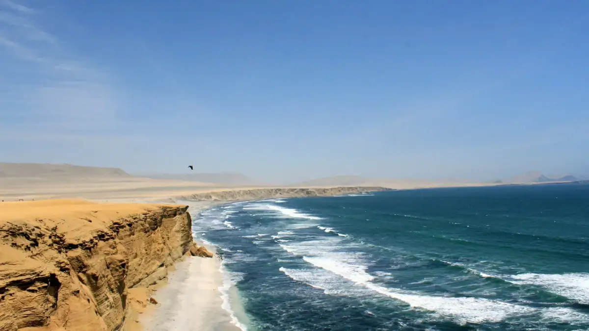
What defines this coast is its extreme aridity: the Humboldt Current cools the Pacific waters and prevents rainfall, creating one of the driest coastal deserts in the world. Lima receives on average only 10 mm (0.4 in) of rain a year, less than the Sahara. Vegetation is almost absent, except in the river valleys where Andean rivers create green oases.
Paradoxically, these cold waters are extraordinarily rich biologically: they feed one of the most productive marine ecosystems on the planet, which supports gigantic colonies of sea lions, penguins and seabirds, like those you will see at the Ballestas Islands.
Lima: the essential gateway
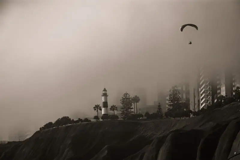
Any exploration of the Peruvian coast begins with Lima, the capital. With some 10 million inhabitants in the metropolitan area, it is one of the largest cities in South America and deserves far more than a night in transit.
The historic center of Lima (Cercado de Lima), a UNESCO World Heritage Site, preserves a remarkable collection of colonial baroque architecture: the Plaza Mayor and its 16th-century cathedral, the San Francisco monastery with its impressive catacombs, and the carved facades of colonial palaces. The trendy district of Miraflores, perched on the Pacific cliffs, offers spectacular views from Kennedy Park and Larcomar.
But Lima is above all known as the food capital of Latin America. Peruvian ceviche has been raised to an art form here: fresh fish marinated in lime juice, ají amarillo and onions, served with choclo corn and sweet potato. Lima cuisine blends Indigenous, Spanish, African, Chinese and Japanese influences in a creativity that can hold its own against the world’s great cuisines.
Allow at least 2 days in Lima for the historic center, Miraflores, the Barranco district and a dinner at one of the fine-dining restaurants that put the city on the world map. To go deeper into this stop, see our guide Visiting Lima: the capital’s essentials.
Hotels in Lima
From Miraflores boutique hotels to Barranco's designer places, find your ideal accommodation in Lima to begin exploring the coast.
Paracas and the Ballestas Islands: the wild Pacific
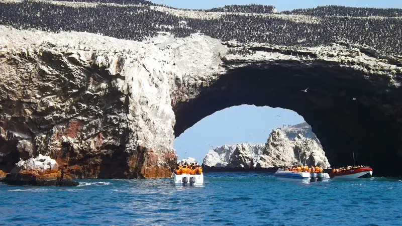
About 260 km (162 mi) south of Lima (3 h 30 to 4 h by bus), the Paracas Peninsula is home to one of Peru’s most spectacular nature reserves. The Paracas National Reserve protects a unique coastal ecosystem: reddish cliffs plunging into the ocean, pinkish sand beaches, salt lagoons populated by flamingos, and strikingly rich marine wildlife.
The Ballestas Islands: the “poor man’s Galápagos”
The Ballestas Islands (in fact an archipelago of rocky islets) can be reached by boat from the port of Paracas in about 2 hours round trip. The excursion is spectacular: the islands shelter colonies of several thousand South American sea lions (Otaria flavescens), colonies of Humboldt penguins (a species endemic to the cold current), thousands of cormorants and blue-footed boobies, as well as dolphins that often accompany the boats.
On the coastal cliff, before reaching the islands, you will see the Paracas Candelabra, a mysterious geoglyph 180 m (590 ft) tall drawn on the hillside, whose origin (pre-Inca? colonial?) and meaning remain debated. Some archaeologists link it to the Paracas culture (about 800 BC to the early Common Era), contemporary with the creators of the Nazca Lines.
The nickname “poor man’s Galápagos” is a bit reductive: while the Galápagos offer greater biodiversity, the Ballestas Islands let you get very close to impressive wild animal colonies, for a fraction of the cost.
Practical info: Boats generally leave at 8 and 10 am from the port of Paracas. The reserve visit is generally done by bus or 4×4 in the afternoon (entry: about 11 soles, about $3; check with SERNANP). Allow a full day for both.
Exploring the Paracas reserve
Beyond the islands, the mainland reserve deserves exploring. Playa Roja (Red Beach) owes its color to feldspar in the sand, a striking lunar landscape. The Catedral, a natural arch sculpted by marine erosion (before its partial collapse in the 2007 earthquake), and the Lagunilla viewpoint are the other highlights.
Paracas and Ballestas Islands excursions
Cruises to the Ballestas Islands, 4×4 tours in the reserve and combined Ballestas + Huacachina excursions from Lima or Paracas.
Huacachina: the oasis in the heart of the desert
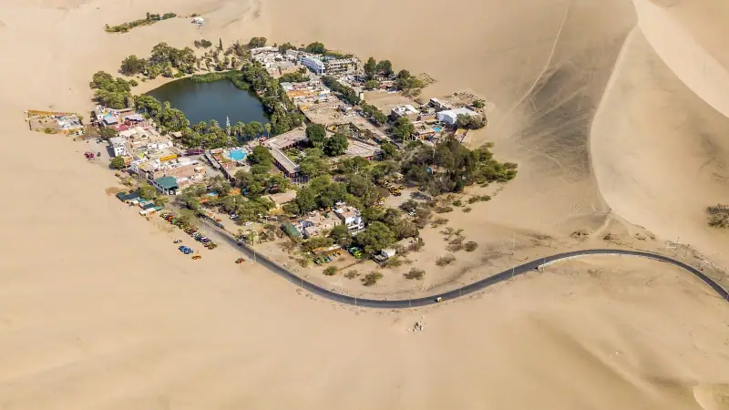
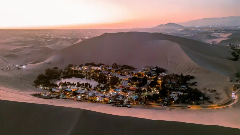
About 5 km (3 mi) from the center of Ica (300 km / 186 mi from Lima, about 4 hours by bus), an improbable sight awaits the traveler: a turquoise freshwater lagoon nestled in a hollow of sand dunes that reach 200 to 500 m (650 to 1,640 ft) in height. Huacachina is one of the few natural oases in the Americas.
This small village of about a hundred residents is encircled by dunes, and its palm trees are reflected in the calm waters of the lagoon. The contrast is striking: on the left, the beige and golden sandy expanses of the dunes; on the right, the lush green of the palms and the blue of the water.
Sandboarding and dune buggies
The main activity in Huacachina is to rush down the dunes by sandboard or to cross them aboard dune buggies. Buggy excursions, about 2 hours long, generally leave in the early afternoon to enjoy the golden light of sunset on the dunes. They include several sandboard descents and climax on the crests of the highest dunes for a breathtaking panorama.
Tip: Book your buggy excursion directly on arrival or through your accommodation: prices are standardized and departures are in groups of 10 to 12 people.
Wines of the Ica region
The Ica region is also known as Peru’s main wine-growing area and the cradle of Pisco, Peru’s national grape brandy. The bodegas (wineries) of the Ica valley offer visits and tastings all year. The Pisco Sour, Pisco mixed with lime juice, egg white and sugar syrup, is Peru’s signature cocktail.
The Nazca Lines: one of the world’s most fascinating mysteries
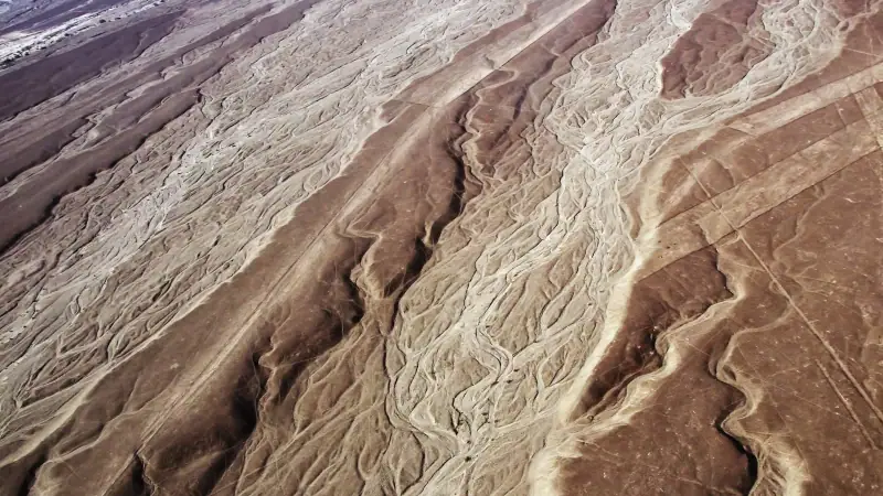
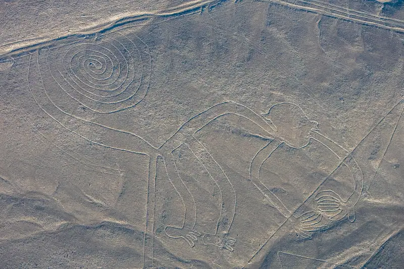
About 460 km (286 mi) from Lima (6 to 7 hours by bus), the Nazca Lines have been a UNESCO World Heritage Site since 1994. Drawn in the desert between 200 BC and AD 600 by the Nazca civilization, these giant geoglyphs, some extending over more than 200 m (656 ft), depict animals (hummingbird, monkey, spider, whale, condor), geometric figures and perfectly straight lines stretching for kilometers.
Flying over them in a small plane: the essential experience
The only way to appreciate the scale and precision of the Nazca Lines is a flight in a small plane from Nazca airport. Flights last about 30 to 45 minutes and let you see about a dozen major figures from the air. The sight is striking: these lines, drawn with extraordinary precision in a desert with no relief perceptible from the ground, testify to astonishing technical mastery and social organization.
From the Pan-American Highway, an observation tower lets you see three figures (the hummingbird, the tree and the hands) from the ground without taking a plane, an option for travelers on a tight budget, even though the experience is far less impressive than a flight.
Practical info: Flights leave from Nazca airport (Maria Reiche airport, a few kilometers from the town center). Several companies offer regular flights. Beware of motion sickness: the small planes bank sharply so that all passengers can see the figures.
The mysterious Nazca civilization
Beyond the lines, the town of Nazca helps you understand the civilization that created them. The Antonini Museum displays Nazca ceramics, textiles and mummies found in the region. A few kilometers from town, the ruins of Cahuachi, the main Nazca ceremonial center, are among the least visited and most fascinating pre-Hispanic sites on the coast.
Trujillo and Chan Chan: the largest adobe city in the world
Peru’s north coast is the cradle of brilliant pre-Inca civilizations, whose traces are still visible in extraordinary archaeological sites. Trujillo, about 550 km (342 mi) north of Lima (8 hours by bus or 1 hour by plane), is the capital of this region and the ideal base to explore these wonders.
Chan Chan: royal city of the Chimú
Chan Chan is the largest adobe (sun-dried mud brick) city in the world and the most impressive pre-Inca archaeological site on the coast. Capital of the Chimú empire, which controlled the north coast between the 9th and 15th centuries before being conquered by the Incas, Chan Chan covered about 20 km² (7.7 sq mi) at its height and potentially housed between 40,000 and 60,000 inhabitants according to UNESCO estimates.
The site, a UNESCO World Heritage Site since 1986, is also listed as endangered because of damage caused by El Niño episodes (torrential rains that erode the adobe). The Tschudi Palace, partially restored and open to the public, gives an idea of the splendor of the royal city: huge courtyards with relief friezes depicting fish, waves and birds, burial chambers and sophisticated irrigation systems.
Chan Chan is about 5 km (3 mi) west/northwest of Trujillo, on the coastal road to Huanchaco, reachable by taxi or minibus.
The Huacas del Sol y de la Luna
A few kilometers south of Trujillo, the pyramids of the Moche culture (AD 100-700) are among the most spectacular pre-Hispanic monuments in Peru. The Huaca del Sol was, at its height, the largest adobe structure in pre-Columbian America. The Huaca de la Luna (smaller but better preserved) reveals polychrome friezes decorated with Aiapaec, the Moche decapitator god, of striking precision and beauty.
Lima – Trujillo flights
Save time on the north coast: 1 hour by plane from Lima versus 8 hours by bus. Fares are frequently under €60 one way (about $70).
Chiclayo and the Lord of Sipán
About 200 km (124 mi) north of Trujillo (3 hours by bus), Chiclayo is a lively city whose main attraction is the Royal Tombs of Sipán Museum (Museo Tumbas Reales de Sipán). This museum, opened in 2002, houses the funerary treasures of the Lord of Sipán, a Moche warlord who died around AD 250-300 and was discovered in 1987.
The discovery of this intact royal tomb was hailed as one of the most important archaeological discoveries of the 20th century in the Americas. The funerary adornments (gold masks, pectorals, necklaces of turquoise and shells) bear witness to goldsmithing of extraordinary sophistication for the time.
The museum is designed as an initiatory journey: you descend from the roof to the basement, reproducing the very structure of the tomb, surrounded by reconstructions and authentic objects lit in the half-light. A museum experience among the best in Peru.
Practical info: The museum is in the Lambayeque district, about 12 km (7 mi) from the center of Chiclayo. Open Tuesday to Sunday. Allow 2 to 3 hours for the full visit.
Máncora: the best beaches in Peru
To end your exploration of the Peruvian coast on a seaside note, Máncora is the place to go. Located in the far north of Peru, about 120 km (75 mi) from the Ecuadorian border, Máncora has warmer waters than the rest of the Peruvian coast (the Humboldt Current loses strength at this latitude) and a tropical climate in the austral summer.
Máncora is known for its regular waves favorable to surfing (the main beach produces good right-hand swells), its ocean sunsets and its relaxed atmosphere. The village has kept its authentic character despite tourist development: fresh seafood restaurants, music in the evening, and a community of international surfers.
To reach Máncora from Lima, overnight buses are the classic option (about 17 hours). From Chiclayo, allow about 7 hours (326 km / 203 mi via the Panamericana Norte).
Rental car on the Peruvian coast
Explore the north coast at your own pace: the Pan-American Highway is well maintained and a car will give you access to archaeological sites off the tourist circuits.
Getting around the Peruvian coast
The Pan-American Highway (Panamericana Sur and Norte routes) is the backbone of the Peruvian coast, running along the ocean from north to south. It is one of the best roads in Peru.
By long-distance bus: Cruz del Sur, Oltursa and Tepsa offer comfortable buses between all the major coastal cities. Overnight buses (cama) are an economical and practical option: you sleep during the trip and arrive early in the morning. Fares are markedly lower than domestic flights.
By plane: To save time on long distances (Lima–Trujillo, Lima–Chiclayo), domestic flights are available with LATAM Perú and Sky Airline. Fares are frequently affordable if booked in advance.
By local taxi/mototaxi: For local trips (between town and archaeological sites, for example), taxis are plentiful and inexpensive. Mototaxis (motorized three-wheelers) are the cheapest option for short distances.
Which itinerary on the Peruvian coast?
South coast itinerary (5-6 days from Lima)
Days 1-2: Lima: historic center, Miraflores, food. Day 3: Paracas: morning, Ballestas Islands; afternoon, Paracas National Reserve. Day 4: Huacachina (Ica): oasis, dunes, buggy and sandboarding at sunset. Day 5: Nazca: day on the lines, flight in a small plane. Day 6: Return to Lima or continue to Arequipa.
North coast itinerary (6-7 days from Lima)
Days 1-2: Lima: historic center, markets, food. Day 3: Flight or overnight bus to Trujillo. Afternoon: Huacas del Sol y de la Luna. Day 4: Chan Chan, the Chimú royal city. Afternoon: Huanchaco beaches. Day 5: Bus to Chiclayo. Visit the Sipán museum (in Lambayeque). Days 6-7: Bus to Máncora. Beach, surfing, rest.
See our 2-week Peru circuit to fit the coast into a fuller trip including the Andes and Machu Picchu.
Practical information for the Peruvian coast
When to go
The Peruvian coast has two very distinct seasons:
- Austral summer (December to April): Plenty of sun, coastal temperatures of 77 to 86 °F (25 to 30 °C), sea suitable for swimming (notably at Máncora). This is the high tourist season and the ideal period for beaches and Nazca flights (best visibility).
- Austral winter (May to November): Lima and the south coast are covered in a gray mist (the garúa) that can make days dull. Temperatures remain mild (64 to 72 °F / 18 to 22 °C) but the sky is often overcast. Nazca and the north coast remain practicable.
Tip: If you combine coast and Andes, go in June to August for the Andes (ideal dry season for trekking) and plan the coast for December to February to enjoy the coastal sun.
Indicative daily budget on the coast
- Tight budget: €25-40 / day (about $29-46) (hostel, local meals, bus)
- Mid-range: €55-80 / day (about $64-93) (3-star hotel, restaurants, excursions)
- Comfort: €100-180 / day (about $115-210) (boutique hotel, premium activities, Nazca flight included)
The Nazca flight is the main expense: allow about €80 to 120 per person (about $95 to 140) depending on the length of the flight and the company. See our Peru budget guide for a complete estimate.
Safety on the coast
The Peruvian coast is generally safe for travelers. Lima calls for the usual precautions of a big metropolis: avoid isolated parts of the Centro Histórico at night, do not flash your phone or camera in the street, and take trusted taxis (Uber and InDriver work well in Lima). Tourist towns such as Paracas, Huacachina and Máncora are very safe.
The Peruvian coast is an invitation to radical change of scenery. From the burning desert of Nazca to the cold waters of the Ballestas, home to sea lions, from the ancient adobe city of Chan Chan to the Huacachina dunes appearing like a mirage, each stop on this coastal itinerary reveals an unexpected Peru, far from Andean clichés. Add the food of Lima, perhaps the best cuisine on the continent, and you will understand why the Coast deserves far more than a simple transit to the airport.
To prepare your whole trip, see our complete guide to Peru.
Frequently asked questions
What is there to see on the Peruvian coast besides Lima?
The Peruvian coast is full of wonders: the Paracas nature reserve and the Ballestas Islands (sea lions, Humboldt penguins), the Huacachina oasis and its giant dunes, the mysterious UNESCO-listed Nazca Lines, the Chan Chan ruins near Trujillo (the largest adobe city in the world) and the tropical beaches of Máncora in the north.
How many days do you need to explore the Peruvian coast?
Allow at least 7 to 10 days to cover the essential stops from Lima: 2 days in Lima, 1 day for Paracas and the Ballestas, 1 day for Huacachina/Ica, 1 day for Nazca, then 2 days in Trujillo/Chan Chan. Add 2 to 3 days for Chiclayo and Máncora if time allows.
How do you get around the Peruvian coast?
The Pan-American Highway (Panamericana Sur and Norte) runs along the whole Peruvian coast. Comfortable long-distance buses (Cruz del Sur, Oltursa, Tepsa) link all the major coastal cities. Renting a car is possible but hardly necessary thanks to the excellent bus connections. For Nazca, some travelers prefer the overnight bus from Lima to save time.
Is it better to visit the north or the south coast of Peru?
It depends on your interests. The south coast (Lima–Paracas–Nazca) is richer in archaeological sites and spectacular desert landscapes. The north coast (Trujillo–Chiclayo–Máncora) combines exceptional pre-Inca civilizations and beautiful tropical beaches. The best option is to combine both in a 2-week circuit from Lima.
What is the best season to visit the Peruvian coast?
The south coast (Lima, Paracas, Nazca) is dry all year but covered in mist (garúa) from May to November. The austral summer (December to April) offers the best beaches and the greatest visibility. The north coast (Máncora) has a tropical climate, with the beach usable from October to April.
Can you see the Nazca Lines from the ground?
Some figures are visible from the road (the hummingbird, the tree and the hands from the observation tower on the Pan-American Highway), but to appreciate the whole and the scale of the Nazca Lines, a flight in a small plane is essential. Flights leave from Nazca airport and last about 30 to 45 minutes.
Are the Ballestas Islands accessible all year?
Yes, boats to the Ballestas Islands leave from the port of Paracas all year, generally at 8 and 10 am. The most favorable season is the austral summer (December to April) for calmer seas. Penguins, sea lions and blue-footed boobies are present all year.
More Peru guides
Keep reading
Visiting Arequipa: Complete Guide to Peru's White City
Complete Arequipa guide: Santa Catalina Monastery, Colca Canyon, UNESCO, hotels and practical tips for your stay in Peru's White City.
Visiting Cusco: Complete Guide to the Former Inca Capital
Complete Cusco guide: Plaza de Armas, Qorikancha, Sacsayhuamán, San Blas, Sacred Valley. Where to stay, food, the Boleto Turístico and itineraries.
Visiting Machu Picchu: Complete Guide to the Lost Inca City
Everything to know to visit Machu Picchu: tickets, circuits, how to get there, Huayna Picchu, Aguas Calientes, best season and practical tips.
Ready-made
Peru itineraries
7 days
Peru in 7 Days: The Ideal One-Week Itinerary
LimaCuscoAguas CalientesCusco
12 days
Peru Sierra Road Trip: 12 Days from Cusco to Huaraz
12-day Peruvian Sierra road trip: Cusco, Machu Picchu, Lake Titicaca, Arequipa, Colca, Huaraz. Complete itinerary with budget.
4 days
Lima, Paracas, Huacachina and Nazca in 4 Days by Bus: Doable Without a Car?
Lima, Paracas, Huacachina and Nazca in 4 days by bus: stages, km, real travel times, recommended departures and what to sacrifice to keep the pace.