What to see
Visiting La Palma: a complete guide to the green island of the Canaries
We may earn a commission when you book through links on this page, at no extra cost to you. We don't visit or try the places we cover: we summarize published sources. How we work
In short
- Plan 4 to 5 days for the essentials: Caldera de Taburiente, Roque de los Muchachos, the Tajogaite lava zone and Santa Cruz. With 3 days, skip the north.
- A rental car is essential; mountain roads are narrow and winding, so a small car beats an SUV.
- Roque de los Muchachos (2,426 m / 7,959 ft) is one of the best stargazing sites in the northern hemisphere; bring warm clothes.
- Budget runs about €55-75 (~$64-87) a day on a small budget and €160-200 (~$185-230) for comfort.
La Palma is not the island you choose by default. It is not at the top of beach rankings or in package-tour catalogs. And that is exactly what makes it one of the most fascinating destinations in the Canary archipelago.
Nicknamed La Isla Bonita (the Beautiful Island), it is also the steepest of all the Canary Islands for its size. Its monumental volcanic caldera is among the largest in the world, its Los Tilos laurel forests are a UNESCO Biosphere Reserve (a status extended to the whole island in 2002), its starry nights are among the best in the northern hemisphere, and its Tajogaite volcano reminded everyone in 2021 that Canary geology is very much alive. Add distinctive wines, preserved colonial architecture and hikes you won’t find anywhere else, and you get an idea of what awaits a curious traveler.
Here is the complete guide to planning your stay on La Palma, from the Caldera de Taburiente to the black lava beaches, with some of the best stargazing nights in Europe.
The Caldera de Taburiente: the heart of the island
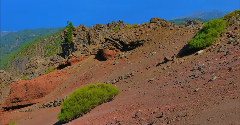
The Caldera de Taburiente National Park is the hub around which everything else is organized. This huge volcanic depression, 7 to 10 km (4 to 6 mi) across with walls that can exceed 1,500 m (4,900 ft), has been a national park since 1954. It is not the result of a single eruption but of gradual collapse combined with millennia of intense erosion. The result is a natural amphitheater of daunting beauty.
How to get into the caldera
The Mirador de La Cumbrecita, reached by car from Los Llanos de Aridane, is the park’s great viewpoint. The road climbs in tight switchbacks through a Canary pine forest, with striking views at every bend. From La Cumbrecita, trails mostly lead to viewpoints, Lomo de las Chozas and Roque Huso. To go down to the floor of the caldera, you need to start from the Mirador de Los Brecitos (or from Dos Aguas, on the Barranco de Las Angustias side).
Note: Access to La Cumbrecita by private car is subject to a quota in high season (book ahead on the park’s website). Outside the quota, you can use a shuttle from the El Paso visitor center.
The essential trails
The GR 131 trail runs along the northern rim of the caldera (Roque de los Muchachos) and crosses the island from north to south, from Garafía to Fuencaliente: it is one of the most spectacular hikes in the Canary Islands. Crossing the caldera floor is done on other trails, such as Los Brecitos – Playa de Taburiente. To spend the night, the Playa de Taburiente camping area is the only one allowed, with a mandatory permit, and the whole thing demands good physical condition.
For a day hike, the trail from Los Brecitos to Playa de Taburiente (about 2 h 30 on foot), continuing into the Barranco de Las Angustias to the Cascada de Colores, is within reach of any walker with good shoes. The floor of the caldera, with its basalt walls, vegetation and river, justifies the effort (plan for the return climb).
Level: Moderate to difficult depending on the trail. Bring water, a waterproof jacket (it can rain even in nice weather) and hiking shoes.
Guided hikes in the Caldera de Taburiente
A naturalist guide will show you the geology, endemic plants and secrets of the caldera, safely.
Roque de los Muchachos and stargazing
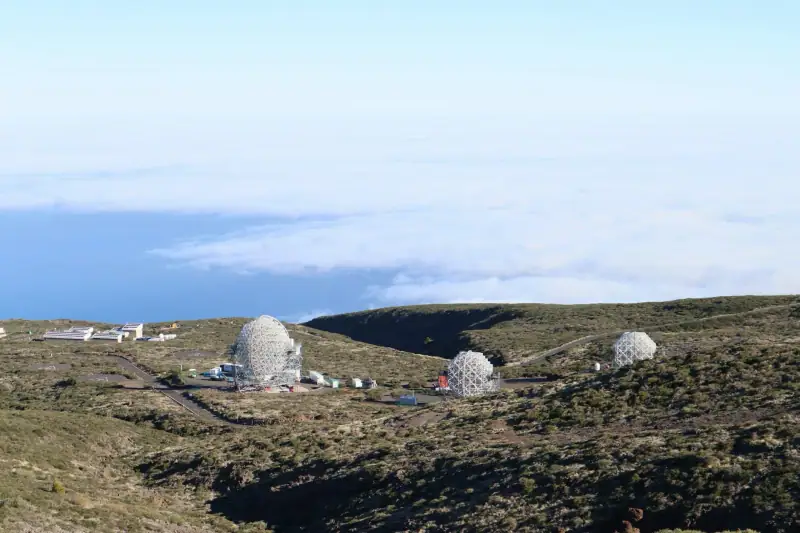
At 2,426 m (7,959 ft), Roque de los Muchachos is the highest point on La Palma and one of the most renowned astronomical observation sites in the world. The Roque de los Muchachos Observatory, run by the Instituto de Astrofísica de Canarias (IAC), houses about twenty telescopes belonging to institutions from twelve countries, including the Gran Telescopio Canarias (GTC), one of the largest optical telescopes in the world, with a mirror 10.4 m (34 ft) across.
Why the La Palma sky is exceptional
Three factors combine to make La Palma a top astronomy site:
- Altitude: At over 2,400 m (7,875 ft), the observatories sit above a sea of clouds that blocks light pollution and low-altitude humidity.
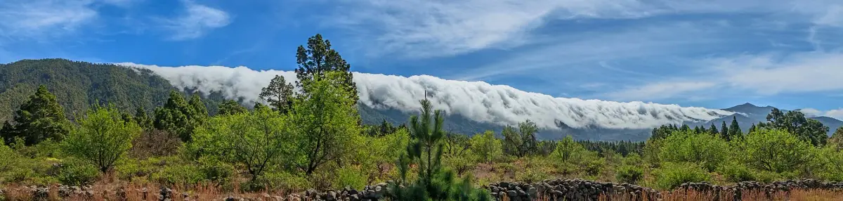
- Temperature inversion: A stable layer of air usually forms below 1,500 m (4,920 ft), trapping the clouds and leaving the sky above perfectly clear.
- The sky law: The Ley del Cielo (Sky Law), passed in 1988, strictly regulates public lighting across the whole island. La Palma is now the world’s first Starlight Biosphere Reserve.
How to enjoy the starry sky
On your own: Drive up to the Roque at night (the road is open, but check weather conditions in winter). Park near the viewpoint and face north or south depending on the season. No equipment needed: on a moonless night the Milky Way is visible to the naked eye the way you have probably never seen it from Europe.
On a guided tour: Several local operators offer observation evenings with professional telescopes, led by astronomers or naturalists. These sessions usually include transport from Santa Cruz de La Palma or Los Llanos de Aridane, setup at a dark site and explanations of the visible constellations. Expect about €50-70 (~$58-81) per person for a 2-3 hour session.
Tip: Bring warm clothes even in summer. At 2,400 m (7,875 ft), nights are cool (10-15 °C / 50-59 °F in July-August, 0-5 °C / 32-41 °F in winter). A hat and a fleece jacket are essential.
Stargazing night on La Palma
See the clearest starry sky in Europe with a professional astronomer and a high-performance telescope.
The Ruta de los Volcanes and Tajogaite
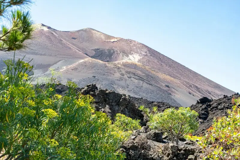
The Ruta de los Volcanes (GR 131 southern section) follows the island’s central volcanic ridge, from the Refugio de El Pilar (Cumbre Vieja Natural Park) to the outskirts of Fuencaliente in the south. The trail crosses a lunar landscape of volcanic cones, fields of hardened lava and pine forests growing back on the ash, one of the most remarkable hiking routes in the Canary Islands.
The Tajogaite volcano: the 2021 eruption
From September 19 to December 13, 2021, the Tajogaite volcano (on the flanks of the Cumbre Vieja) erupted after 50 years of silence. In under three months, the lava flow covered more than 1,000 hectares (2,470 acres), destroyed several thousand homes and created a new coastal delta on the west of the island, adding more than 40 hectares (about 100 acres) of land to La Palma.
The eruption caused one direct death, from inhaling toxic gases. The preventive evacuation of more than 7,000 residents was nonetheless remarkably effective in limiting the human toll.
Visiting the lava flow area
Since 2022, the accessible areas around Tajogaite have been gradually reopened. Miradores (viewpoints) let you see the extent of the flow from the road. Guided tours authorized by the Cabildo Insular take visitors onto the hardened lava to understand the geology and the story of the eruption.
The area is both a fascinating geological record and a human memorial: building roofs, swimming pools and church steeples sometimes emerge from the hardened lava, a reminder that several whole villages were swallowed.
Access: From Los Llanos de Aridane, take the LP-213 toward El Paraíso. Viewpoints are signposted. Some trails still require a permit, so ask at the local tourist office.
Santa Cruz de La Palma: the colonial capital
Santa Cruz de La Palma is one of the best-preserved colonial towns in the Canary Islands. Its historic center, protected as a site of cultural interest, lines up 16th- and 17th-century facades with their typical carved wooden balconies. The waterfront (Avenida Marítima), with its pastel-colored houses, is the town’s emblematic image.
The old town on foot
The historic heart is centered on Plaza de España and El Salvador cathedral (16th century). The Calle Real district is the main pedestrian street, lined with shops, cafés and historic houses. The cedar-wood balconies, typical of Canarian architecture, are exceptionally well preserved here.
The Placeta de Borrero and the neighboring lanes keep the feel of a town that seems to have stopped in the age of the galleons. Several historic houses are open to visitors.
The museums
The Naval Museum (Museo Naval) is housed in the Barco de la Virgen, a replica of Christopher Columbus’s caravel Santa María, a 15th-century ship built in 1940 by local craftsmen. The Insular Museum (Museo Insular), in the former San Francisco convent, traces the island’s geological and cultural history. Modest entry fees, with explanations in Spanish and English.
The covered market
The Mercado Municipal in Santa Cruz is the best place to buy local products: palmero cheese, almonds, bananas, figs and wines from the La Palma Denominación de Origen.
La Palma’s beaches: lava and the Atlantic
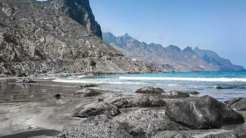
La Palma is not an island of white sand beaches. Its shores are dominated by black volcanic sand or lava pebbles, a trait that adds to its authenticity and sets it sharply apart from its neighbors.
Los Cancajos
About 3 km (2 mi) south of Santa Cruz de La Palma, Los Cancajos is the main beach on the east coast. Its fine black volcanic sand, calm water protected by a natural breakwater and its facilities (showers, sun loungers, restaurants) make it the busiest beach on the island. Ideal for family swimming.
Charco Azul
On the northeast coast, Charco Azul is a natural pool carved into volcanic rock. Atlantic waves rush in and out, creating a natural bath surrounded by black lava sculpted by erosion. The sight of the waves crashing on the surrounding rocks is striking. Free access, no facilities there.
Tazacorte
On the west coast, Tazacorte and its small fishing port have a black pebble beach where the Atlantic sunsets are spectacular. The port’s fish restaurants (seafood, catch of the day) are well regarded on the island. The road down from Los Llanos de Aridane runs through banana plantations, the emblematic farming landscape of the west coast.
Playa de Puerto Naos
On the southwest coast, Puerto Naos had the island’s most developed black sand beach, with its hotel infrastructure. The area was severely affected by the 2021 eruption: CO₂ emissions made the sector uninhabitable and closed to visitors for several years. Reopening is gradual: access to the village requires authorization (QR code), and swimming at Playa Chica was allowed again in July 2026, but the “black zone” remains closed. Before you go, check the opening status with the Cabildo de La Palma.
La Palma food and wine
La Palma’s cooking is Canarian cuisine at its most authentic, enriched by the specialties of an island of farms and vineyards.
Local food
The essentials you will find in any traditional restaurant on the island:
Papas arrugadas con mojo: Local potatoes (endemic varieties with small tubers) cooked in very salty water until wrinkled, served with mojo rojo (tomato, chili pepper, cumin, garlic) or mojo verde (cilantro, garlic, oil). This is the base of Canarian cooking.
Gofio: Toasted grain flour, used since ancient times. It is found in soups (escaldón), desserts or sauces.
Queso palmero: La Palma cheese is one of the most renowned in the Canary Islands. It has a Denominación de Origen and can be fresh, semi-cured or aged, smoked with paprika (with a characteristic reddish rind). Don’t leave the island without taking some home.
Almonds: La Palma almonds, grown mostly in the north and west of the island, go into many local pastries, such as rapaduras and marzipan. Miel de palma, a syrup made from Canary palm sap, is, by contrast, a specialty of neighboring La Gomera.
Grilled fish: Vieja (parrotfish), sama (red porgy) and cherne (wreckfish) are the signature species on coastal restaurant menus.
La Palma wines
The island has its own wine appellation, Denominación de Origen La Palma, and produces high-altitude wines (up to 1,400 m / 4,590 ft for some plots) from native grapes such as Malvasía, Bujariego, Verdello, Listán blanco, Albillo, Sabro and Negramoll.
The Canary Malvasía (Malvasía Volcánica), a natural sweet wine made on black lava, is the best-known specialty. La Palma’s dry white wines, from ungrafted (pre-phylloxera) vines, are increasingly recognized by international critics.
The wineries in the Fuencaliente area (south) and Garafía (north) welcome visitors for tastings, an experience worth adding to any stay.
Where to stay on La Palma
La Palma doesn’t have the big hotel chains of the neighboring islands, which is an advantage if you want authenticity. Lodging is split between boutique hotels in town, rural houses (casas rurales) inland and a few beach hotels on the coast.
Santa Cruz de La Palma
The capital is ideal for those who want to explore the town and make day trips from it. The small hotels in the historic center offer location and charm.
Good to know: Casas rurales, renovated farmhouses rented by the night or the week, are the most authentic and often the most affordable option on La Palma. The local rural tourism organization (Asociación de Turismo Rural de La Palma) has an online catalog.
Los Llanos de Aridane
The island’s second town, Los Llanos is a good base for the west (Tazacorte, beaches, access to the Caldera de Taburiente). More residential and less touristy than Santa Cruz, it has good local restaurants and an authentic atmosphere.
Rural houses inland
For an immersive stay in the heart of the laurel forests or mountain vineyards, casas rurales tucked away inland (Tijarafe, Garafía, Barlovento areas) are unmatched. You will definitely need a car.
Hotels and rural houses on La Palma
From charming town-center hotels to casas rurales in the heart of the forests, find the best lodging for your travel style.
Visiting La Palma: what to see first
To visit La Palma, keep four essentials in mind: the Caldera de Taburiente, Roque de los Muchachos at night, the Tajogaite volcano area and Santa Cruz de La Palma. Allow 4 to 5 days to see them without rushing, and 3 days at the strict minimum if you skip the north of the island.
| Place | Why go | Suggested time | Watch out for |
|---|---|---|---|
| Caldera de Taburiente (Los Brecitos, La Cumbrecita) | Hiking in the caldera, Cascada de Colores, viewpoints | 1 day | Quota in high season, book ahead |
| Roque de los Muchachos | Highest point (2,426 m / 7,959 ft), sea of clouds, starry sky | Half day or 1 night | Warm clothes, variable weather in winter |
| Tajogaite and west coast | 2021 lava flow, viewpoints, Tazacorte | Half to 1 day | Some trails require a permit |
| Santa Cruz de La Palma | Colonial center, museums, covered market | 3 to 4 hours | Easy on foot |
| Los Tilos and the north | Laurel forest, waterfalls, Garafía vineyards | 1 day | Narrow, winding roads |
Visiting La Palma in 3 days or a week
With 3 days, do the Caldera de Taburiente on day one, Roque de los Muchachos and then a stargazing night on day two, and the Tajogaite area with Tazacorte on day three. Visit Santa Cruz at the end of the day on arrival or departure.
With a week, add the north (Los Tilos, Garafía), a day on the Ruta de los Volcanes, a wine tasting in Fuencaliente and a real rest day at Los Cancajos beach. The day-by-day detail is in the itinerary below.
Where to stay and how to get around
La Palma is small but mountainous: distances in kilometers are misleading, because roads are slow. To cover the whole island, pick a central base. Santa Cruz suits fans of towns and museums, Los Llanos de Aridane suits hikers and the west coast. Our guide to where to stay on La Palma compares the areas. A rental car remains essential to see the island at your own pace.
Suggested itinerary: 5 days on La Palma
Day 1: Arrival in Santa Cruz de La Palma
- Afternoon: Arrive, settle in, first stroll along the Avenida Marítima
- Evening: Visit the historic center, dinner at a restaurant on Calle Real
Day 2: Caldera de Taburiente
- Early morning: Drive to the Mirador de Los Brecitos (permit and reservation recommended in advance)
- Morning to afternoon: Hike in the caldera to Playa de Taburiente and the Cascada de Colores
- Evening: Back to Santa Cruz, dinner of palmero cheese and almonds
Day 3: Roque de los Muchachos and a starry night
- Morning: Drive up to Roque de los Muchachos (1 h 30 by road from Santa Cruz), view of the clouds below
- Afternoon: Hike along the caldera ridges, alpine scenery
- Night: Stargazing (guided tour or on your own)
Day 4: Tajogaite volcano area and the west coast
- Morning: Los Llanos de Aridane, local market
- Afternoon: Drive to the lava flow area, viewpoints, guided visit of the Tajogaite sector
- Late afternoon: Tazacorte, sunset over the Atlantic
- Evening: Fish dinner at the Tazacorte port
Day 5: North of the island and departure
- Morning: Drive north, the Los Tilos laurel forests (San Andrés y Sauces, Biosphere Reserve), waterfalls
- Midday: Lunch in Garafía, local wine tasting
- Afternoon: Back toward Santa Cruz, shop for cheese and almonds
- Evening: Departure or an extra night
To fit La Palma into a multi-island trip, see our guide to island hopping in the Canary Islands. La Palma is often paired with Tenerife or La Gomera.
Practical information
How to get there
By air: Flight options to La Palma depend on the season and your departure city; check airlines and routes before you book. Outside the busiest season, a common connection is through Tenerife North (TFN) or Gran Canaria (LPA) with Binter Canarias (inter-island ATR 72 flights, about 40 min, several flights a day).
By ferry: Fred. Olsen Express (about 2 h 30 crossing) and Naviera Armas (longer crossing, around 4 hours) link Tenerife to Santa Cruz de La Palma; the departure port (Santa Cruz de Tenerife or Los Cristianos) and schedules vary by company and season, so check them before you book. Ideal if you have a car or want to avoid flying.
From the airport: La Palma Airport (SPC) is about 8 km (5 mi) south of Santa Cruz de La Palma. A bus service links the airport to the capital (line 1, about 30 min). A rental car is recommended for exploring the island.
Getting around
La Palma has a bus network (Transportes Insular de La Palma) linking the main towns, but frequencies are limited (1 to 3 runs a day on some lines). A rental car is essential for any serious exploration of the island.
Mountain roads are often narrow, steep and winding. A small city car is better than an SUV for high-altitude roads.
Budget
- Small budget: €55-75 (~$64-87) a day (casa rural or guesthouse room, grocery stores, local restaurants)
- Mid-range: €90-130 (~$105-150) a day (3-star hotel, restaurants, a few tours)
- Comfort: €160-200 (~$185-230) a day (boutique hotel, guided nights, private tours)
La Palma is one of the most affordable Canary Islands: few high-end restaurants, inexpensive rural lodging, no mass tourism. Our Canary Islands budget guide gives you the full benchmarks for each type of trip.
Weather and seasons
La Palma has a transitional microclimate: the east coast (humid trade winds) gets more rain and stays green all year, while the west coast is drier and sunnier. High-altitude areas can be in cloud even in summer. June to October are the most stable months for high-altitude hikes.
To choose the ideal time based on your activities, see our guide to the best time to visit the Canary Islands.
Mountain safety
Hikes in the Caldera de Taburiente and on the Ruta de los Volcanes call for caution:
- Never set out alone on a difficult trail.
- Tell your lodging about your planned route.
- Bring water (at least 2 liters / 2 qt for a day), food, a windbreaker and sunscreen.
- Weather can change quickly at altitude, especially in winter and spring.
- Check trail conditions before you go with the park visitor center (some may close after heavy rain).
La Palma in a few words
La Palma is an island you have to earn. You don’t come here to laze by a pool between two all-you-can-eat buffets. You come to walk in a giant caldera, watch the Milky Way above the clouds, touch lava that has been cooling since 2021 and understand that nature is not done with this archipelago.
Here, the Isla Bonita doesn’t whisper its title: it commands it with raw beauty, ancient laurel forests, villages that seem not to have moved since the galleons and nights of an astronomical clarity unmatched in Europe. If you’re looking for the antidote to mass tourism, you’ve just found it.
Thinking of combining several islands? Our guide to the best hikes in the Canary Islands will help you extend the adventure.
Sources
Frequently asked questions
Is La Palma really worth the detour compared with Tenerife or Gran Canaria?
Yes, if you want something other than beaches and resort hotels. La Palma is the island for hikers, wild nature lovers and astronomy fans. Its landscapes, with laurel forests, a giant caldera and recent lava flows, have no equivalent in the archipelago. Allow 5 to 7 days to enjoy the full range.
Can you still visit the Tajogaite volcano area after the 2021 eruption?
Yes. The exclusion zone has been lifted gradually since 2022. Today you can reach viewpoints over the lava flow and the new coastal delta with a licensed guide or on tours organized by the Cabildo Insular de La Palma. Some trails are still closed, so check current conditions before you go.
Do you need a rental car on La Palma?
Yes, it is essential. Public transport exists but is limited and infrequent. You need a car to reach Roque de los Muchachos, the Caldera de Taburiente, remote beaches and inland villages. Mountain roads are narrow and winding, so take a small city car rather than an SUV.
When is the best time to visit La Palma?
Spring (March to May) and fall (September to November) are ideal: moderate warmth (22-24 °C / 72-75 °F at altitude, 25-27 °C / 77-81 °F by the sea), few crowds and comfortable hiking. Summer is pleasant by the sea but hot and sometimes cloudy at altitude. Winter can bring rain, especially on the east coast, but nights at Roque de los Muchachos are exceptionally clear.
Can tourists go stargazing on La Palma?
Absolutely. La Palma is a Starlight Biosphere Reserve and has the strictest legislation in Europe against light pollution. Nights at Roque de los Muchachos are among the best in the northern hemisphere. Several operators offer guided observation nights with professional telescopes.
How do you get to La Palma?
Flight options to La Palma Airport (SPC) vary by season and departure city, so check airlines and routes before you book. A common connection is through Tenerife North or Gran Canaria with Binter Canarias (inter-island flight, about 40 min). The ferry from Tenerife takes about 2 h 30 (Fred. Olsen Express) to 4 hours (Naviera Armas) depending on the company; check schedules and the departure port before booking.
How many days do you need for La Palma?
Four to five days cover the essentials: the Caldera de Taburiente, Roque de los Muchachos, the Tajogaite area, Santa Cruz and the north of the island. With 3 days, focus on the caldera, Roque de los Muchachos and the west coast. A week leaves time for the Ruta de los Volcanes, wines and the beach.
What is there to do on La Palma if you don't like hiking?
Santa Cruz de La Palma and its museums, the Tajogaite viewpoints, Roque de los Muchachos by car, Los Cancajos beach, the Fuencaliente wineries and the covered market can all be visited without a long walk. A stargazing night takes no physical effort.
More Canary Islands guides
Keep reading
La Gomera: a complete guide to the island of forests and whistled language
La Gomera travel guide: Garajonay, El Silbo, Valle Gran Rey, hiking and food. Everything you need to visit the quietest of the Canary Islands.
Lanzarote: a complete guide to the Canary Islands' volcanic island
Lanzarote guide: Timanfaya, César Manrique, Jameos del Agua, La Geria and Papagayo beaches. Everything you need to plan your trip to the volcanic island.
Visiting Corralejo: Complete Guide to Fuerteventura's Beach Town
Corralejo, Fuerteventura: white-sand beaches, the Corralejo dunes, water sports, where to stay and what to do. A complete guide to plan your trip.
Ready-made
Canary Islands itineraries
5 days
Lanzarote in 5 Days: A Complete Itinerary for the Volcanic Island
5-day Lanzarote itinerary: Timanfaya, Jameos del Agua, Playa Papagayo, César Manrique. A day-by-day plan to make the most of the volcanic island.
Can be adapted in the planner
Island Hopping in the Canary Islands: Visiting Several Islands in One Trip
Island hopping in the Canary Islands: ferries, flights, multi-island itineraries and tips to combine Tenerife, Gran Canaria, Lanzarote and Fuerteventura.
5 days
Tenerife in 5 Days Without a Car: A Realistic Bus and Tram Itinerary
Puerto de la CruzLos Cristianos