What to see
Azores Lakes and Volcanoes: The Main Natural Sites
We may earn a commission when you book through links on this page, at no extra cost to you. We don't visit or try the places we cover: we summarize published sources. How we work
In short
- The Azores have about 88 lakes on six of the nine islands, most in craters or calderas; São Miguel has the most, including Sete Cidades, Fogo and Furnas.
- Montanha do Pico (2,351 m / 7,713 ft) requires advance registration and costs €25 (~$29), with a quota of 320 climbers a day.
- The last land eruption was Capelinhos on Faial (September 1957 to October 1958); Pico last erupted in 1720.
- Algar do Carvão on Terceira was closed for works from October 2024, with reopening announced for around mid-2026: check before you go.
The Azores are a geology lesson on a grand scale. Born of volcanic activity at the junction of three tectonic plates (Eurasian, North American and African), these islands still bear the marks of a past of fire and powerful earth forces, and they remain very visible. Collapsed calderas filled with lakes of unreal colors, volcanic peaks rising from the ocean, fields of solidified lava, basalt caves and steaming geysers: the Azores offer a complete catalog of exceptional geological phenomena.
Understanding Azorean geology
The Azores archipelago was born of volcanism at the junction of three tectonic plates: the Eurasian plate, the North American plate and the African plate. This unique configuration, rare on the planet, explains the intensity and diversity of the volcanic activity. Santa Maria, the oldest island in the archipelago, emerged about 8 million years ago.
The islands continue to form and evolve. Santa Maria is the oldest (about 8 Ma), while Pico is one of the youngest: the island began forming about 300,000 years ago (the oldest volcanic units are dated around that age), with its current summit morphology put in place in the Holocene (radiocarbon dates under 6,000 years for the terminal cone). The oldest part of São Miguel formed about 4 million years ago from the Nordeste volcanic complex, in the east of the island. Faial had its last eruption in 1957-1958 (Capelinhos), which added about 2.4 km² (0.9 sq mi) of new land at the island’s western tip; only about a quarter (~0.6 km² / 0.2 sq mi) remains today, the rest having been eroded by the sea. Pico’s last land eruption ran from July to December 1720 (lava flows from a fissure on the southeast flank reaching the ocean).
Caldera lakes: the jewels of the Azores
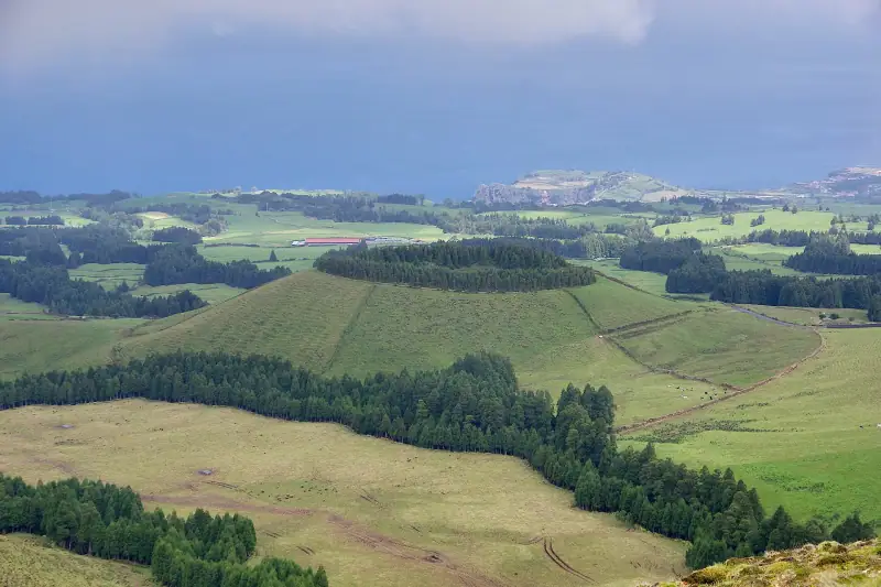
Lagoa das Sete Cidades (São Miguel)
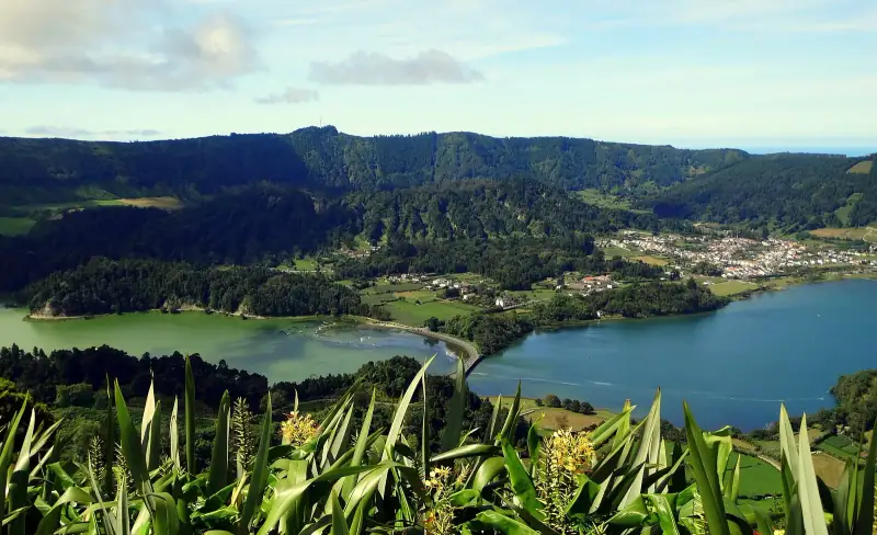
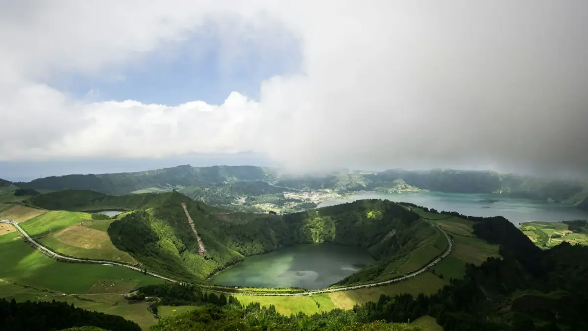
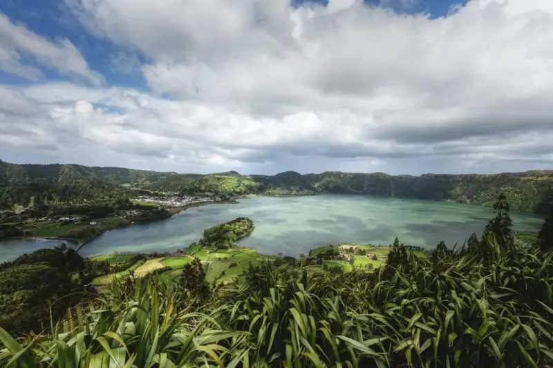
The most famous site in the Azores. The Sete Cidades caldera is a nearly circular volcanic depression about 5 km (3 mi) across, with walls that drop as much as 500 m (1,640 ft). The water surface itself sits at about 260 m (850 ft) of elevation. Inside are two adjoining lakes separated by a thin arm of land and a bridge. Lagoa Azul (blue) and Lagoa Verde (green) form a unique natural picture: together they make up the largest freshwater lake in the Azores (about 4.3 km² / 1.7 sq mi, up to 33 m / 108 ft deep).
- View: Miradouro Vista do Rei (southwest side, named in honor of the visit of the King and Queen of Portugal in 1901) and Miradouro Boca do Inferno (south side, on the ridge, reached by a trail from the regional road)
- Hike: PR4 SMI Mata do Canário – Sete Cidades trail, 11 km (7 mi) one way along the northwest ridge, following the rim of the caldera to the village (about 3 h, easy, source trails.visitazores.com)
- Village: The village of Sete Cidades, inside the caldera, has about 800 inhabitants (793 in the 2011 census)
- Origin: A caldera formed by successive collapses following major explosive eruptions of the Sete Cidades volcanic complex
Local legend says the two differently colored lakes were born from the tears of a green-eyed shepherd and a blue-eyed princess, separated by the young woman’s father because of a forbidden love.
Lagoa do Fogo (São Miguel)
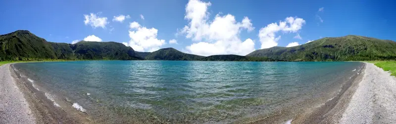
The protected lake. Located in the volcanic massif of the Serra de Água de Pau, Lagoa do Fogo can be reached only by trail or from a viewpoint. The lake, perched at about 575 m (1,886 ft) of elevation and covering 1,360 hectares (3,360 acres), surrounded by green slopes and Macaronesian vegetation, is a striking blue.
- View: Miradouro da Lagoa do Fogo (reachable by car, on road ER5-2A); access is regulated in summer, see our guide Lagoa do Fogo: access, shuttle and trail
- Hike: A steep descent to the lake from the viewpoint; marked PRC02 SMI Praia – Lagoa do Fogo trail (about 11 km / 7 mi, ~4 h) for walkers
- Swimming: Tolerated on the north shore (sand beach) but discouraged (cold water, difficult access, strictly protected area)
- Protection: Regional nature reserve since 1974 (decree-law 152/74 of April 15, 1974, ~2,182 hectares / 5,392 acres), Natura 2000 special area of conservation, Ramsar site
Lagoa das Furnas (São Miguel)
The lake with fumaroles. Lagoa das Furnas is a caldera lake surrounded by dense forests and geothermal springs. On its north shore, in the caldera area, tightly sealed pots are buried in the volcanic ground to cook cozido das Furnas for about 6 hours in geothermal heat (put in the ground early in the morning, taken out between 11 am and 1 pm), an emblematic image of the Azores. Access to the fumarole site is paid (about €3 / ~$3.50).
- Specialties to discover: Besides the cozido, try Terra Nostra Garden and its iron-rich water pool, as well as the Poça da Dona Beija in the village of Furnas: adult entry €12 (~$14) until 5:30 pm, €16 (~$19) from 6:00 pm, 1 h 30 time slot, tickets online only (2026 prices published by the operator, official source pocadadonabeija.com/en/info)
- Walk: Loop trail around the shore (about 10 km / 6 mi, 2 h 30 to 3 h)
- Curiosity: The fumaroles bubble directly on the north shore of the lake
- Village: The village of Furnas is about 2 km (1.2 mi) northeast of the lake (5 minutes by car)
The seven lakes of Flores (Flores)
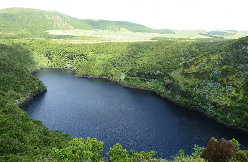
The caldera of many colors. The island of Flores has a system of seven lakes (Sete Lagoas): Lagoa Funda, Lagoa Rasa, Lagoa Comprida, Lagoa Seca, Lagoa Branca, Lagoa Negra and Lagoa da Lomba, spread across a landscape of exceptional beauty. Lagoa Negra, named for its dark waters, reaches a depth of about 113 m (371 ft), the deepest lake in the whole archipelago, while Lagoa Seca holds only temporary rainwater. Lagoa Funda (“deep” crater) and Lagoa Rasa (“shallow” crater) sit side by side at different elevations (~360 m / 1,180 ft and ~530 m / 1,740 ft respectively), which makes their juxtaposition spectacular from the scenic road.
- Key site: The Poço da Alagoinha (also called Poço da Ribeira do Ferreiro), where some twenty waterfalls tumble down a green cliff, one of the most emblematic images of the Azores. A short trail of 2.6 km (1.6 mi) round trip (45 to 60 min) from the Fajã Grande parking area
- Viewpoint: The overlook of Lagoas Funda and Comprida offers one of the most spectacular views in the archipelago
- Official trail: PR3 FLO Miradouro das Lagoas – Poço do Bacalhau (7 km / 4.3 mi one way, difficult, source trails.visitazores.com) to see the lakes from above
Volcano and lake excursions in the Azores
Guided visits of the calderas and geological sites.
Volcanoes and notable geological sites
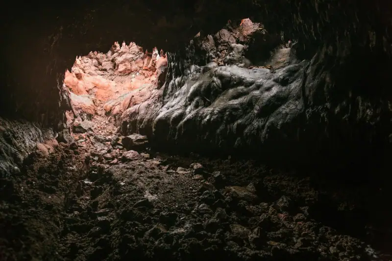
Capelinhos Volcano (Faial)
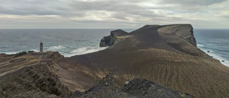
The last land eruption in the Azores. From September 27, 1957 to October 24, 1958 (13 months), a Surtseyan eruption rose from the sea at the western tip of Faial, adding about 2.4 km² (0.9 sq mi) of new land joined to the island (about a quarter, ~0.6 km² / 0.2 sq mi, remains after marine erosion). The eruption displaced nearly 2,000 people and destroyed 300 houses in the parishes of Capelo and Praia do Norte. Followed by scientists around the world, the process became a textbook case in volcanology. The volcanic cone, the gray ash fields and the half-buried lighthouse can be visited today, and an excellent underground interpretation center (Centro de Interpretação do Vulcão dos Capelinhos) traces the story of the eruption.
- Price: €10 (~$12) per adult (museum + lighthouse access)
- Source: parquesnaturais.azores.gov.pt
Algar do Carvão (Terceira)
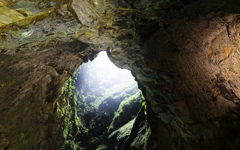
The underground cathedral. This former volcanic chimney (algar) is about 90 m (295 ft) deep and is one of the most impressive volcanic cavities open to the public anywhere in the world. A long staircase leads down to an underground chamber holding a small rainwater lake that can reach 15 m (49 ft) deep (sometimes dry in summer). The basalt walls are lined with amorphous silica stalactites, a rare mineralogical feature in a volcanic setting.
- Price: €10 (~$12) per person for the visit (ticket sold at the entrance by Os Montanheiros)
- Closure: the site has been closed for works since October 2024, with reopening announced for around mid-2026: check that it has reopened before you go
- Access: seasonal hours, managed by the association Os Montanheiros (montanheiros.com)
- What to bring: warm clothing (about 12 °C / 54 °F inside), closed-toe shoes
- Good to know: the archipelago has many volcanic cavities (including the Gruta das Torres on Pico, the longest lava tube in Portugal at more than 5 km / 3 mi), but Algar do Carvão is the most spectacular one open to the public
Montanha do Pico (Pico)
The highest peak in Portugal. At 2,351 m (7,713 ft) (summit of the Piquinho), Pico volcano is visible from the neighboring islands of the central triangle (Faial, São Jorge) in clear weather. Its last eruption ran from July to December 1720. Climbing it is a geological adventure: you cross recent lava fields, basalt flows and volcanic ash up to the summit crater, then the terminal peak.
- Mandatory starting point: Casa da Montanha at 1,230 m (4,035 ft) of elevation (municipality of Madalena), where climbs are registered
- Distance and elevation gain: official PR01 PIC trail, 3.8 km (2.4 mi) uphill (≈ 7.6 km / 4.7 mi round trip), elevation gain of +1,150 m (+3,770 ft); trail marked by 47 markers up to the crater
- Price: €25 (~$29) per person (advance booking required at montanhapico.azores.gov.pt)
- Quota: maximum 320 climbers a day, of which 160 on the mountain at the same time
- Equipment: GPS tracker and safety briefing provided at the start; warm clothing, water and a headlamp are mandatory
- Duration: allow 6 to 8 hours round trip (about 3 h up, slightly more down) depending on fitness
- Difficulty: marked trail but steep, with rocky and unstable ground on the last section; climbing is discouraged in bad weather
Graciosa Caldera (Graciosa)
The human-scale caldera. The summit caldera of Graciosa, a circular depression about 1.6 km (1 mi) across and 350 m (1,150 ft) deep, can be reached on foot and holds the famous Furna do Enxofre, a vast volcanic cave about 194 m (636 ft) long and 50 m (164 ft) high under the vault at its center, considered one of the largest volcanic cavities in the world. At the bottom is a small cold pool. The cave is entered through a 37 m (121 ft) tower housing a spiral staircase of 183 steps, built in the early 20th century. Sulfurous fumes persist in the cave.
The best viewpoints for photographing the calderas
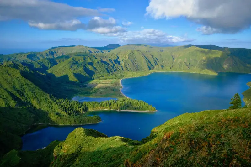
São Miguel:
- Miradouro Vista do Rei (Sete Cidades): the Azores postcard
- Miradouro do Pico Vermelho (Sete Cidades): a view from the other side
- Miradouro da Lagoa do Fogo: a plunging view of the lake
- Miradouro do Pico da Barrosa: a 360° view over the whole island
Flores:
- Miradouro da Lagoa Funda and Miradouro da Lagoa Negra & Lagoa Comprida: a spectacular view of the caldera lakes
- Poço da Alagoinha waterfall (Ribeira do Ferreiro): one of the most photographed sites in the archipelago
Terceira:
- Serra do Cume: a view of the checkerboard pattern of the divided fields
To fit these sites into your trip, see our São Miguel road trip and our 7-day Azores itinerary.
Sources
The factual data in this article (elevations, dimensions, prices, eruption dates, trail lengths) is drawn from the following official sources:
- parquesnaturais.azores.gov.pt: regional natural parks of the Azores (Lagoa do Fogo, Capelinhos, Algar do Carvão)
- montanhapico.azores.gov.pt: booking and official rules for the Pico climb (price €25, quota 320 a day)
- trails.visitazores.com: official registry of the Azores PR trails
- visitazores.com: official tourism office
- pocadadonabeija.com: 2026 prices for Poça da Dona Beija
- montanheiros.com: management of Algar do Carvão and Furna do Enxofre
- whc.unesco.org: UNESCO sites of Angra do Heroísmo and the Pico vineyards
- Wikipedia: geological data, 2021 census, Capelinhos eruption
- Global Volcanism Program, Smithsonian: Pico dating (~300,000 years, last eruption 1720)
Frequently asked questions
Are the Azores volcanoes still active?
Yes, the Azores sit on the Mid-Atlantic Ridge and volcanic activity is permanent. The last land eruption took place on Faial from September 27, 1957 to October 24, 1958 (Capelinhos), and Pico's last one ran from July to December 1720.
Can you go down into the calderas of the Azores?
Yes, you can go down into the Sete Cidades caldera and reach the lake shores. For some more recent calderas, access is restricted for safety reasons.
Why do the Azores lakes have different colors?
The color of the lakes varies with their chemical composition, depth, the angle of the light and the algae present. Sete Cidades has its famous blue and green lakes, two lakes in the same caldera separated by a bridge.
How many lakes are there in the Azores?
The Azores have about 88 lakes spread over six of the nine islands, most of them in volcanic craters or calderas. São Miguel has the most, including the most spectacular (Sete Cidades, Fogo, Furnas).
Do you need a car to reach the calderas?
For most calderas, yes. The access roads to the viewpoints are passable in a standard car. Walks within the calderas are then possible from the parking areas.
More Azores guides
Keep reading
Corvo Island: A Complete Guide to the Smallest Island in the Azores
Complete guide to Corvo in the Azores: the Caldeirão, Vila do Corvo, birdwatching and practical tips for the archipelago's most remote island.
Faial Island: A Complete Guide to the Blue Island of the Azores
Complete guide to Faial in the Azores: the caldera, Capelinhos, Horta marina, beaches and hikes. Everything you need to visit the Blue Island.
Graciosa Island: complete guide to the pearl of the Azores
Complete guide to Graciosa in the Azores: Furna do Enxofre, Santa Cruz, Carapacho hot springs, PDO wines and the UNESCO biosphere reserve.
Ready-made
Azores itineraries
São Miguel Road Trip: Driving Around the Island
A complete guide to driving around São Miguel in the Azores: route, essential stops, road tips and lesser-known spots.
4 days
São Miguel in 4 Days Without a Car: A Realistic Itinerary by Bus and Organized Tour
Can you visit São Miguel without a rental car? A realistic 4-day itinerary with public buses, organized tours, schedules, prices and distances.
5 days
São Miguel in 5 days with kids: stops, miles and a realistic pace
5 days on São Miguel (Azores) with kids: day-by-day stops, distances and drive times, naps, swims, whales and pace pitfalls to avoid.
Can be adapted in the planner